From Above: Schuylkill River from South Street, 1927

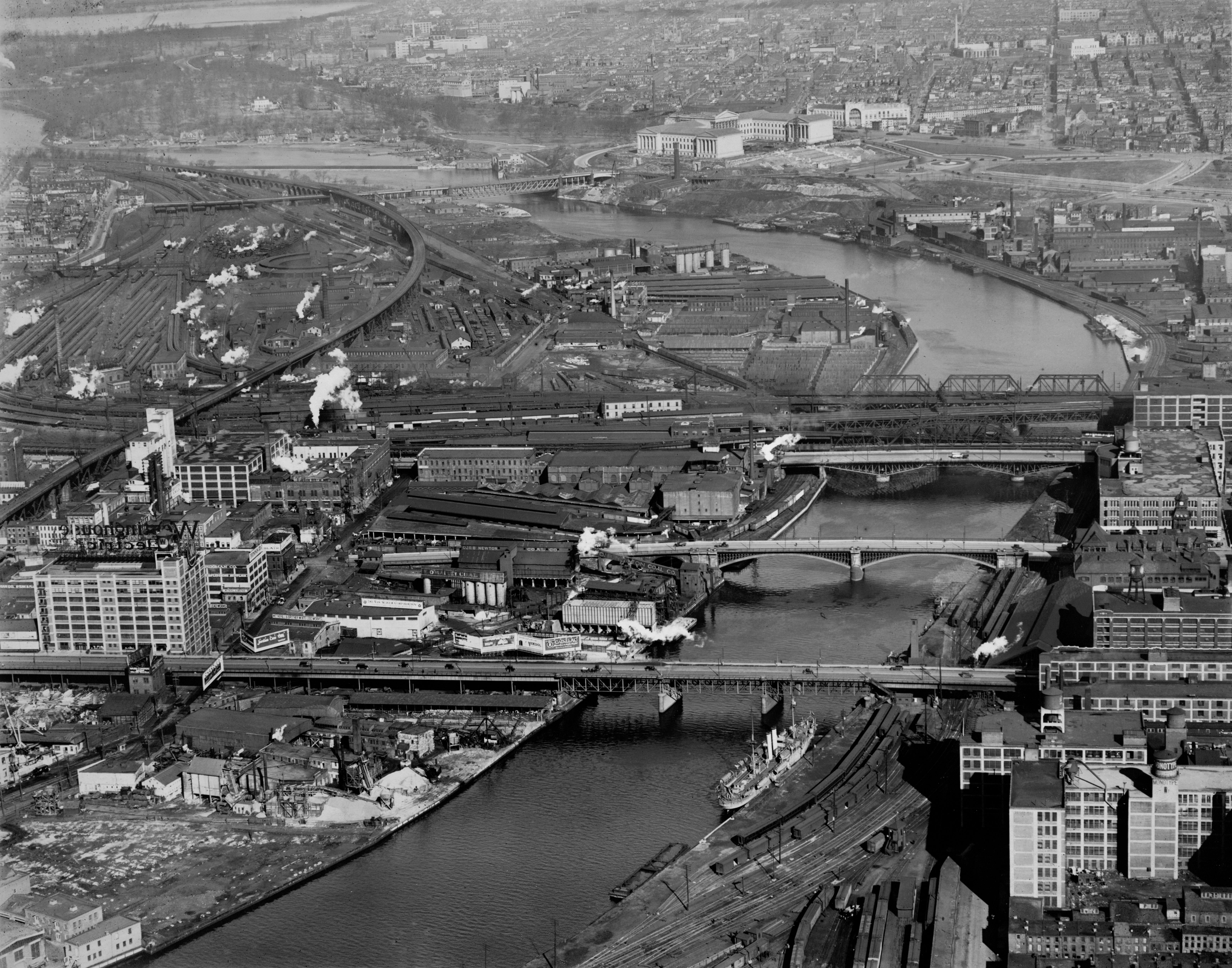
In honor of the Schuylkill bridges sporting new lighting here’s a look back at these crossings from December 31,1927 looking north from above South Street with a view of the hard working river, hard at work.
In this view looking up the tidal Schuylkill River we see sites both familiar and long gone.
Bridges drawing Walnut, Chestnut and Market streets over the river are there, though they’ve certainly over the decades. But the sections of the Center City and University City that abut the river today couldn’t look more different.
At the top of the frame, Boathouse Row, Lemon Hill and the Waterworks are recognizable, while the new art museum and the Parkway are clearly taking shape. Neither the Post Office nor 30th Street Station had been built yet, nor had Penn and Drexel started to reach eastward. Before all of that, on either side of the river, manufacturing and an earlier generation of infrastructure dominate.
On the western banks there are coal, ice and lumberyards, vast Pennsylvania Rail Road train yards, metal works and warehouses. Rail lines, docks and industry dominated the eastern edge of the river where we now enjoy the Schuylkill Banks recreational trail. Some of the rail infrastructure remains today, including the freight line that runs along the Schuylkill River Trail, the rail bridge over the river now used by SEPTA, and the yards north of where 30th Street Station stands.
But for all that has changed there are several buildings visible here that are vestigial reminders of the hard working waterfront that ran through the city. On the western side of the Walnut Street Bridge there is the AFSCME building, then used by Westinghouse Electric (note the huge sign). On the eastern side of the river, we can see the building that is now Locust on the Park sporting a water tower that reads “Monotype”. The Lanston Monotype Manufacturing Company, a pioneering typesetting firm based in Philly, was located here. And just north of it, there is the building we know as Locust Point, a former garage and warehouse. Just above that, at the eastern end of the Chestnut Street Bridge, the building with the clock tower was a B&O railroad station.
Click here to enlarge, and tell us what you see.
The aerial image above is part of the Free Library’s Print and Picture Collection, and is used by PlanPhilly/Eyes on the Street with the express permission of Aerial Viewpoint, which owns these aerial images. For reproductions or permissions inquiries contact Aerial Viewpoint.
To learn more background about these aerial photographs, head over here.
WHYY is your source for fact-based, in-depth journalism and information. As a nonprofit organization, we rely on financial support from readers like you. Please give today.


