First tropical storm of 2017 forms far from land

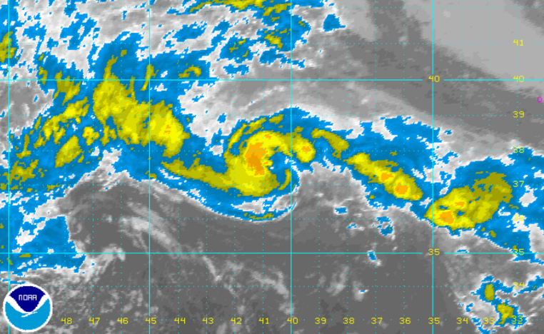
NOAA infrared satellite imagery of Tropical Depression One this afternoon.
The 2017 Atlantic hurricane season is getting an early start with the first tropical storm forming Thursday far from land.
Tropical Storm Arlene is situated about 815 miles west of the Azores in the central Atlantic Ocean, according to the National Hurricane Center.
The system, containing maximum sustained winds of 45 miles per hour is heading to the west-northwest, near 25 miles per hour. It unexpectedly increased to tropical storm strength this afternoon.
“I have to add one more surprise to my long hurricane forecasting career,” National Hurricane Center forecaster Lixion Avila wrote in the center’s afternoon update. “Tropical storms in April are rare, and Arlene is only the second one observed in this month during the satellite era. It should be noted, however, that this type of storm was practically impossible to detect prior to the weather satellite era.”
Forecasters say it is likely to weaken on Friday.
This is the third consecutive year that a tropical system has formed in the Atlantic basin before the official beginning of hurricane season on June 1.
Earlier this month, Dr. Phil Klotzbach and Michael M. Bell of Colorado State University released an annual outlook that calls for “slightly below average” tropical cyclone activity.
The outlook calls for a 42 percent probability of at least one major hurricane striking the United States and a 24 percent chance of an Eastern seaboard strike.
Both percentages are below the yearly averages, including 52 percent for the United States and 31 percent for the Eastern seaboard.
The forecasters cite the cooling tropical Atlantic over the past month and the currently colder than normal North Atlantic as inhibiting factors that tend to “force atmospheric conditions that are less conducive for Atlantic hurricane formation and intensification.”
But they warn coastal residential that it only takes one hurricane striking the coast “to make it an active season for them, and they need to prepare the same for every season, regardless of how much activity is predicted.”
Some Atlantic basin seasons feature below average activity but still result in a devastating storm, like Hurricane Andrew in 1992, while others like 2010 — the third most active season on record — did not feature a hurricane making landfall.
The report cautions that while forecasting precision is impossible in April, the general public is curious about what’s possibly in store for them.
“We issue these forecasts to satisfy the curiosity of the general public and to bring attention to the hurricane problem. There is a general interest in knowing what the odds are for an active or inactive season,” the authors note. “One must remember that our forecasts are based on the premise that those global oceanic and atmospheric conditions which preceded comparatively active or inactive hurricane seasons in the past provide meaningful information about similar trends in future seasons.”
The 2017 Atlantic basin hurricane season continues through November 30. The first names include Arlene, Bret, Cindy, Don, Emily, Franklin, and Gert.
NOAA offers a comprehensive guide on storm preparations. The agency’s “Hurricane Preparedness Week” runs from May 7 through May 13.
WHYY is your source for fact-based, in-depth journalism and information. As a nonprofit organization, we rely on financial support from readers like you. Please give today.

