Cold week ahead: Polar vortex to invade; few snow chances

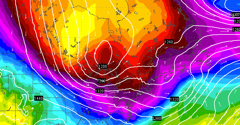
The Monday 06z GFS forecast model temperature map for Wednesday evening, indicating the arrival of polar air. While the map depicts temperatures about a mile above the surface, it is useful in demonstrating the airmass.
Here we go again!
The recent mild and tranquil weather ends today as a wintry pattern returns, delivering arctic air by mid-week and a few unimpressive snow chances.
The culprit?
It’s once again the polar vortex, which is “essentially a mass of very cold air that usually hangs out above the Arctic Circle and is contained by strong winds,” said AccuWeather.com Senior Meteorologist Alex Sosnowski in a report.
While based on recent news reports it may seem like a new concept, it always exists at the poles, according to the National Weather Service office in New York, NY.
“The polar vortex is not something that will be visibly observed like tornadoes, funnel clouds, thunderstorms, lighting, etc.,” a graphic issued by the National Weather Service office notes. “The polar vortex is not something in itself dangerous to humans, but the cold, arctic air associated with them at the surface could be.”
But while the week will be cold, especially beginning Wednesday, the arctic blast won’t be as severe as back in January.
The National Weather Service office in Mount Holly, NJ forecasts temperatures about 10 degrees below normal Thursday, Friday, and Saturday, then potentially plunging to around 15 to 25 degrees below normal on Sunday.
And with cold air, precipitation will fall as snow, but the following threats appear minor at best:
A fast moving system is expected to drop one to three inches of snow throughout the region Wednesday morning, with some spots seeing four inches, according to a forecast discussion issued by the National Weather Service office in Mount Holly.
A chance of snow showers Friday night into Saturday.
So when will this relentless wintry cycle end?
“As far as a break in the pattern, and some more sustained normal or above normal temperatures, no signs of it yet,” said John Homenuk, lead forecaster at New York Metro Weather. “But we’re watching carefully for the first appearance of a respite in the wintry pattern on the model guidance.”
WHYY is your source for fact-based, in-depth journalism and information. As a nonprofit organization, we rely on financial support from readers like you. Please give today.

