City Planning Commission holds first public meeting for Lower Northeast District

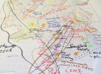
Seven tables, 14 city planners and seven maps marked up in blue, red, black and orange filled a Friends Hospital conference room last night.
They were signs of the first of three community planning meetings for the Lower Northeast District – the Philadelphia City Planning Commission’s distinction for Frankford, Northwood, Summerdale, Lawncrest, Oxford Circle and part of Castor Gardens. The district is one of 18 identified by the commission and is next on tap to develop ideas for future planning and zoning opportunities under the comprehensive Philadelphia2035 plan.
These neighborhoods have changed drastically in the last 10 to 20 years. In 1990, the district was 89 percent white and 72 percent of residents owned their homes. By 2010, the district was 30 percent white, 46 percent black and 23 percent Latino. Not quite 56 percent of residents were homeowners. The unemployment rate in the district is higher than the city’s total, but the Naval Support Activity center in Lawncrest and Cardone Industries in Summerdale employ almost 9,000 people combined.
But you don’t have to tell any of that to the district’s residents, employees and church-goers who attended last night’s meeting. They see for themselves everyday the changing demographics and economic hardships. So they gathered around the seven large maps with two city planners each and shared ideas.
Orange stars marked Northwood Academy Charter, Sankofa Freedom Academy, the Navy Depot, Castor Avenue’s restaurants and other neighbor-defined landmarks and destinations. Angry red squiggles highlighted obstacles – physical and otherwise – that are keeping the neighborhoods from feeling unified. The Market-Frankford Line, Roosevelt Boulevard and complicated intersections like Oxford Circle, Oxford Avenue and Levick Street, and Adams Avenue/Langdon Street and Roosevelt Boulevard all got squiggles on the maps.
Monique Young had a solution for those red squiggles. She lives in West Philadelphia but her church and youth development program are in Lawncrest. And she’s proposing skybridges – elevated crosswalks – to help make Roosevelt Boulevard more pedestrian-friendly. Those spots on the map were marked in black on her group’s map as areas of focus.
The nearly two-hour meeting ended with the seven groups looking at each other’s maps to compare who had considered what to be neighborhood drawbacks or assets.
Many agreed with Tim Leaman’s ideas. He’s a member of the Oxford Circle Mennonite Church, and he’d like to see better acces to the area around Fels High School, Cardone and the Navy Depot. That chunk near the northwest part of the district was marked in several colors on every map.
The maps are expected to make a little more sense by June, when the next district meeting will be held. By then, the city planners will have gotten together to compare the seven maps and find commonalities to present a single, unified map to the district. Following a final district meeting in August, the plan is expected to be adopted in October to help the district implement positive neighborhood changes.
WHYY is your source for fact-based, in-depth journalism and information. As a nonprofit organization, we rely on financial support from readers like you. Please give today.


