


Citizens map their ideas for Philly of the future
-

One workgroup maps ideas for Philadephia 2035
-

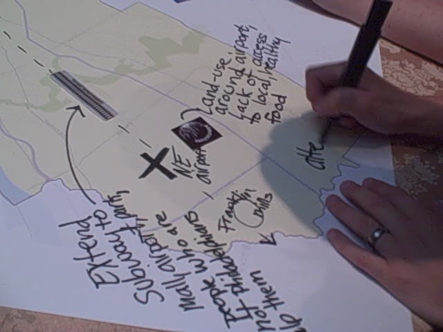
A closeup of one group's developing vision for the Northeast
May 27, 2010
By Kellie Patrick Gates
For PlanPhilly
With paper icons representing transit, parks, housing and other city building blocks and a seemingly endless stream of ideas, about 90 people spent Thursday night creating maps of what they hope Philadelphia will be like in 2035.
All were participants in the Philadelphia City Planning Commission’s first public input session for Plan2035 – the long-range comprehensive plan that will be completed in about five years.
Attendees were divided into teams of five or six people. Each team sat at a round table with a large map of the city in the middle.
Those gathered at the Pennsylvania Academy of Fine Arts were about to launch into about an hour’s worth of discussion and debate that would result in a literal map showing where the group thought things like transit improvements, green space, neighborhood centers (essentially a Main Street), industrial, agricultural and residential areas should go. Combined with the results from three future sessions, the maps will help the city’s planners craft the new master plan.
But before the planning games began, the participants were given a little background and some guidance.
https://www.youtube.com/watch?v=G_b5h6olZBU
“We are preparing the first comprehensive city-wide plan for our city in 50 years,” Alan Urek, the PCPC’s director of strategic planning and policy, told those gathered at the PAFA. “The last one was done by Ed Bacon.”
That plan led to a lot of successes and key features of the city today, Urek said. Penn Center and the development of the North East and South West portions of the city, for example, all have roots in that plan.
Perhaps the biggest failure of the last plan, done in 1960, is that it projected Philadelphia’s population, then about 2 million people, to grow to about 2.5 million. Instead, the population diminished, he said. “We overbuilt.” And now, there are more public facilities than the city can support and some are in disrepair.
Urek said that Plan2035 will be both a vision of the future and a roadmap of how to get there. “Big, transformative ideas take a lot of time and resources,” he said. “We must plan for them well in advance.”
https://www.youtube.com/watch?v=k207QVt0qQQ
Danielle DiLeo Kim, the planning commission’s director of special projects, gave a run-down of the process that would result in the new plan. Internally, monthly meetings have begun with representatives from every city department. Plan2035 team members are also meeting with a group of 25 “local thought leaders,” Kim said, including people in neighborhood leadership positions and developers.
“The comprehensive plan cannot be fully adopted unless we have buy-in from city council, which means we have to have it from you all,” she said.
The planning process is about six months into a five-year process, she said. This year, a city-wide plan will be devised. In the subsequent years, more detailed plans will be developed for each of 18 geographical areas. These are larger than neighborhoods. The most easily recognized slice is the Center City portion, she said. That one will run from Girard Ave. to Washington Ave, and will include the many neighborhoods that fall within that area.
https://www.youtube.com/watch?v=6mMz96YwVzI
Community Planner Jennifer Barr established the guidelines for the evening, and the teams began their work.
At one table, facilitator Beige Berryman, a planning department urban design specialist, kept track of a flurry of ideas from city residents Kara Lindstrom, Larry Weintraub, Len Neely, David Curtis and Kendra Lawton.
Berryman said at the get-go that she wouldn’t tape an icon down or write a description of how that particular building block would be expressed at that location without group consensus. Mostly, that came pretty easily.
Lawton, who works for the Cultural Alliance, kicked things off by suggesting a new transit stop near the Art Museum. She lives in South Philadelphia, and said it is very tough to get to the Art Museum area from many parts of the city without a car.
Later in the discussion, the group built on her suggestion. Soon, they were using transit to link the Philadelphia Museum of Art with Centennial Park, where the Please Touch Museum now is.
https://www.youtube.com/watch?v=Zf2x7YDnm0Y
Weintraub, an architect who lives in Bella Vista and has given tours for the Preservation Alliance for the past 20 years, suggested covering I-95 in Center City. Berryman said the exercise was about thinking big – did the group want to propose a larger area to cover? But the group went with the original suggestion when Weintraub pointed out that in other areas, there is more land between the big highway and the water with which to work. So the Center City cover would have the biggest impact.
Everyone in the group agreed that there wasn’t enough of a transit connection between Northeast Philadelphia and Center City, and that portions of the Northeast seemed underutilized. Before long, a new town center emerged on the map. The first step was extending the Market-Frankford El line so that users could take it to Pennypack Park, the Northeast Airport and industrial park, and Frankford Mills Mall.
This was a place where some industry – perhaps green industries – could be more developed, the group decided. And there was also room for more housing, and even agricultural use.
https://www.youtube.com/watch?v=21mhVSvygHQ
The group proposed a similar community center in the East Oak Lane/West Oak Lane/Olney area. Here, public transit from Center City would be extended, but so would Route 309 from the suburbs. With the dense housing in the area, some compatible industry would give residents a place to work without a big commute, Lindstrom suggested. The area is in need of green space, everyone agreed, and Lindstrom said she saw no reason why that green space couldn’t be at least partly productive – in other words, agricultural.
The group also suggested more green space and denser residential zoning for Chinatown.
A quick trip around the room to look at the half-dozen maps created showed some big ideas in common. Most of the groups wanted to bring some sort of rail service to the Northeast portion of the city, for example – although many chose to build a light rail line on Roosevelt Boulevard instead of extending the Market-Frankford. Some wanted to cap portions of I-95. Other ideas included improving north-south transportation in West Philadelphia and eliminating vacant housing city wide.
At the end of the night, all of the maps were collected by the Plan2035 team.
Further public mapping sessions are scheduled for June 1 at the Please Touch Museum from 6:30 p.m. to 8:30 p.m.; Esperanza College, Monday, June 7 from 6:30 p.m. to 8:30 p.m.; and Knowlton Mansion, Tuesday, June 8 from 6:30 p.m. to 8:30 p.m.
Contact the reporter at kelliespatrick@gmail.com
WHYY is your source for fact-based, in-depth journalism and information. As a nonprofit organization, we rely on financial support from readers like you. Please give today.
Brought to you by PlanPhilly

PlanPhilly
In-depth, original reporting on housing, transportation, and development.

A vacant church in Philadelphia’s Strawberry Mansion will become workforce housing
The $10 million project will reuse Cornerstone Baptist Church on North 33rd Street. The property has sat vacant for more than five years.
3 hours ago

Thousands of West Philly tenants remain in limbo as city considers saving 925 affordable rentals
The city missed its exclusive window to bid on the homes, opening the door to outside buyers and possible displacement.
1 day ago
Listen 1:12
A rare Keith Haring mural in Point Breeze may join Philly’s historic register
The “We the Youth” artwork revives a long-running debate among preservationists over whether murals should be protected as historic landmarks.
1 week ago
Listen 0:54