Hurricane Michael packs 110-mph winds as it heads toward Florida panhandle
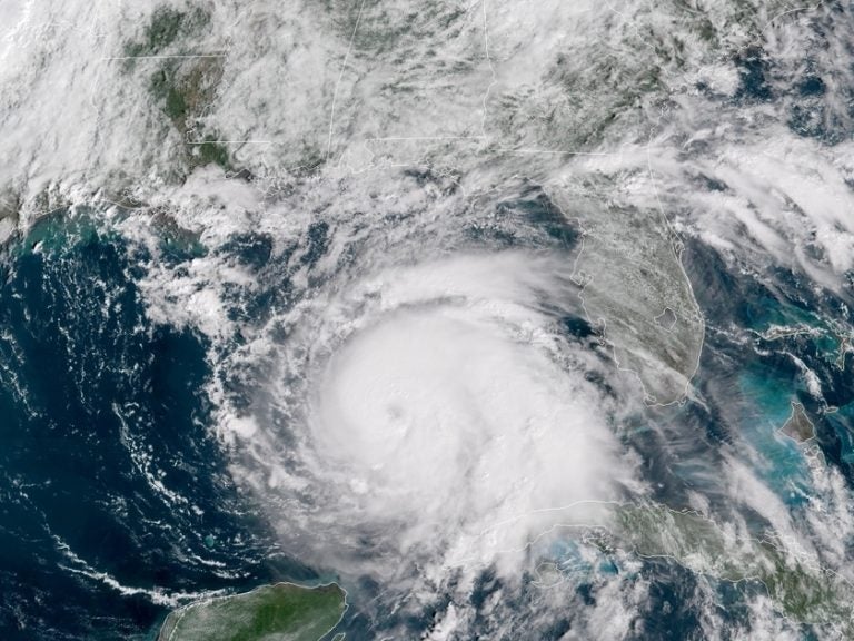
(NOAA/STAR)
Updated at 2:30 p.m. ET
Hurricane Michael has rapidly grown into a strong Category 2 storm, with sustained winds hitting 110 mph on Tuesday — just 24 hours after gaining hurricane status, according to the National Hurricane Center. Michael is expected to make landfall along the Gulf Coast on Wednesday as a Category 3 storm.
Hurricane Michael is forecast to be the most destructive storm to hit the Florida Panhandle in decades. It’s expected to send life-threatening surges of ocean water into coastal areas along the Gulf, from Pensacola around the coast to Tampa.
The storm’s rapid intensification over the past two days, despite shifting winds, “defies traditional logic,” according to the hurricane agency. Forecasters predict Michael will bring torrential rains and winds upwards of 125 mph.
Just before 2 p.m. ET Tuesday, Michael was 310 miles south-southwest of Apalachicola, Fla., moving north at 12 mph.
#HurricaneMichael isn’t heading to any one town…
There are warnings for more than 300 miles of coastline. It’s forecast to be a large and dangerous hurricane at landfall.
✔️Life-threatening storm surge
✔️Damaging winds
✔️Life-threatening flash floodinghttps://t.co/VyWINDk3xP pic.twitter.com/nsHYkBjy2r— NWS (@NWS) October 9, 2018
“Today is the day. We need to be ready for this,” NHC Director Ken Graham said in an update Tuesday morning, urging people in the storm’s path to finish preparations and evacuate if they’re in an emergency area.
The National Hurricane Center has enacted hurricane, tropical storm and storm surge warnings for more than 300 miles of the Florida coast. Coastal counties began issuing evacuation orders and opening emergency shelters at schools on Sunday, as member station WFSU reports.
Wakulla County issued a dire warning, saying it won’t open any of its shelters — because they’re safety-rated only for storms up to Category 2 strength, WFSU reports.
“The center of Michael will continue to move over the southern Gulf of Mexico this morning, then move across the eastern Gulf of Mexico later today and tonight,” the agency said. The storm’s center is expected to move inland over the Florida Panhandle or Florida Big Bend area before moving northeastward across the Southeastern U.S.
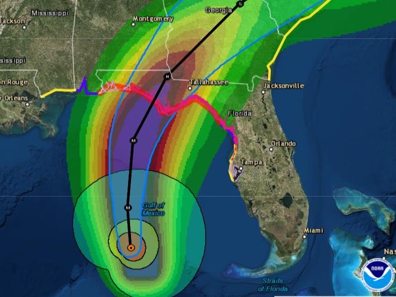
Everyone in hurricane and storm surge warning zones should prepare for life-threatening winds, the NHC said. As Michael moves inland, southern Georgia and southeastern Alabama can expect damaging winds, too.
“Hurricane Michael is a monstrous storm,” said Florida Gov. Rick Scott, at a Tuesday morning news conference, adding that it could bring “total devastation to parts of our state, especially in the Panhandle.”
President Trump has approved Florida’s declaration of emergency. “As Hurricane Michael nears landfall, we are working with state and local officials in Florida to take all necessary precautions,” Trump said Monday. “It looks like another big one.”
FEMA is already on the ground in Florida; other federal agencies are also preparing to assist people in the storm’s path.
The governor activated 750 National Guardsmen for storm response on Monday, on top of the 500 activated the day before. The Florida National Guard has over 4,000 more Guard members available for deployment, Scott said.
The NHC says some coastal regions can expect 8 to 12 feet of storm surge, as the hurricane’s winds drive a wall of water onto the low-lying shore.
Panama City could see a storm surge at depths from 6 to 9 feet. But the surging seawater could also create perilous problems far from the coast, raising rivers and bays to dangerous levels as it pushes as much as 10 to 15 miles inland.
“The storm surge is absolutely deadly. Do not think you can survive it,” Scott said. The governor has declared a state of emergency in 35 counties and is stressing that residents should “absolutely” evacuate if ordered to.
“Think about what we’ve seen before with storms like Hurricane Irma,” he said. More than 80 deaths were linked to that storm, according to The Associated Press — including residents of a nursing home.
With a number of counties ordering evacuations, Scott waived highway tolls in the northwest part of the state.
After it makes landfall, the storm is predicted to pass into Georgia, where Gov. Nathan Deal on Tuesday issued a state of emergency covering 92 counties — nearly the entire lower two-thirds of his state.
For residents who want to leave, local authorities are stressing timely evacuation, too.
“Storm surge is the No. 1 problem that you can see from these storms. You have rain, you have wind — but storm surge, that’s a lot of water that can come onshore,” said David Peaton, the assistant director of emergency management in Levy County in an interview with local station WUFT.
Peaton says he is working closely with the National Weather Service to provide accurate information and protective measures to his county, which faces the Gulf of Mexico and is especially vulnerable to any flooding produced by Michael. Levy County has closed its schools through Thursday; Florida State University, in Tallahassee, has closed as well.
Both Peaton and Scott encourage residents to have at least three days’ worth of food and supplies and to check on their neighbors and monitor local news coverage.
Citing data from aircraft that flew in the storm, the hurricane center says Michael is becoming better organized and symmetrical as it moves north.
Both NOAA and Air Force Reserve Hurricane Hunter aircraft have flown through the hurricane’s four quadrants — and the NHC says, “The planes actually passed through the eye around the same time [Tuesday morning], and reported that they could see one another.”
Tallahassee International Airport is suspending commercial flight activity as 12:01 a.m. ET on Wednesday but expects to resume activity on Thursday.
Florida Fish and Wildlife has put 40 additional law enforcement officers on notice to deploy with a variety of special equipment, including boats that can be used for high-water rescues.
9(MDAzMzI1ODY3MDEyMzkzOTE3NjIxNDg3MQ001))


