Traveling down the modern Mississippi
The Mississippi’s history is as winding as the river itself. But it’s also part of our modern landscape.
Listen 49:01
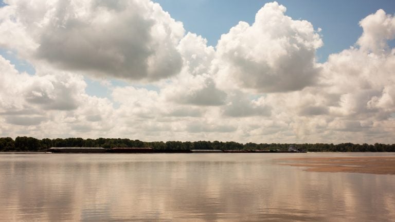
Island 63 lies in the Mississippi River by Clarksdale, Mississippi. The island doesn’t always appear on maps because its shape, size, and exact location often changes depending on the level of the river and floods. (Irina Zhorov/WHYY)
The words ‘Mississippi River’ evoke images of a mustachioed Mark Twain — or the whistle of a steamboat calliope.
“But that river doesn’t exist anymore,” says historian Christopher Morris, author of “The Big Muddy: An Environmental History of the Mississippi and Its Peoples from Hernando de Soto to Hurricane Katrina.”

Click on a point on this map to jump down the river.
The Mississippi is the largest river in the United States by volume. It’s the second largest by length. Water from more than 40 percent of the country ends up in its current. In the north, it’s fast-moving and clear but travel south below St. Louis and the river is almost a different waterway — muddy, broad, slow.
The river has built cities and washed them away. It has killed people and made fortunes for others. As a nation, we’ve engineered the river to try to protect people and property. Years ago, we were intimate with the water — young lovers courted by rowboat in the midst of flood waters. But today, people living by the Mississippi often fear it.
The Mississippi’s history is as winding as the river itself. But it’s also part of our modern landscape. We’ll travel down this mighty river, trying to update the image of the Mississippi. Sorry, Mark Twain.
A sacred grain grows in the Mississippi

BY ALEX STERN
Jeff Savage has been harvesting wild rice for over fifty years. He’s loved eating the nutty, smoky grain for even longer.
“My mom and dad would try to cook wild rice after we’d go to bed,” he remembers. “And the smell of that wild rice would wake us up. And we’d jump out of bed and say, ‘I smell wild rice cooking!'”
Wild rice grows in the headwaters of the Mississippi River, along the banks and in many of the surrounding lakes.
Savage is a member of the Ojibwe, a tribe of North American indigenous people. According to oral history, Ojibwe migrated from the east coast following a prophecy that they would find a sacred food growing on the water. Now, wild rice is part of their ceremonies, feasts, and cultural identity.
“To be Ojibwe means to be wild rice people,” Savage says.
Each fall, the Ojibwe harvest wild rice. Savage says his people care for the grain, rather than farming it. “Farmers are really manipulating the land and the environment, whereas a caretaker works more with the environment,” he says.
“You’re part of a natural ecosystem.”
The reintroduction of a native fish

BY PAIGE PFLEGER
The alligator gar looks prehistoric — it has the long nose and protruding teeth of an alligator but the cylindrical body and fins of a fish. In Illinois, the last known alligator gar was caught in 1966, weighing in at 130 pounds and measuring more than seven feet long. This particular gar was native to the rivers of Illinois but disappeared from those waters about 50 years ago.
“There was a lot of them that were killed just for the sake of getting rid of them, getting them out of the water,” says Dan Stephenson, chief of fisheries at the Illinois Department of Natural Resources. “People don’t like their looks so there’s a lot of them that, when they’re caught, they’re killed or thrown on the bank.”
But he says the biggest issue for the alligator gar has been habitat loss.
Now, the Illinois Department of Natural Resources and the U.S. Fish and Wildlife Service are working to reintroduce the alligator gar to its native waters.
“We don’t know if we’ll be successful,” Stephenson says, “But we’ve got an opportunity to try.”
Tearing down homes to protect the river

BY ZACH DYER
Yellow “caution” tape fences off the front yard of a shabby two-story brick home in the Wells Goodfellow neighborhood of St. Louis.
The house is about to be demolished. It’s miles away from the riverfront but part of a region-wide project to clean up the Mississippi River. The city’s aging sewer system sends overflow sewage into the river during heavy rainstorms — more than 13 billion gallons of contaminated wastewater goes into the river every year, according to the Environmental Protection Agency.
After the EPA sued the city in 2007, St. Louis set off on a colossal effort to clean up its act through a mix of traditional infrastructure upgrades and more novel approaches to pollution reduction.
Solomon Craighead is on the demolition crew. “We going to gut the building out, take everything down, crush it up and haul everything off,” Craighead says. “But once we go through here, you’re going to see a pretty lot.”
The idea behind the “pretty lot” he described is to turn brick and asphalt into green spaces that act like sponges to soak up rainwater during a storm. Put enough of these “sponges” in the city, and they can cut down the number of overflows into the river.
Craighead says neighbors are excited to see the demo crew pull down a vacant home. He calls it a “domino effect.”
“You’re helping the environment and you’re also cutting down on crime,” he says. “Everything is working together and when it works together it comes together, it’s good.”
Preparing for floods after the levee fails

BY MAX GREEN
From the road, all you can see of Sean Pecord’s house is a roof and the top of a flagpole, which flies the American flag above the revolution-era Gadsden flag, bright yellow, with its “Don’t Tread On Me” slogan stitched beneath a coiled snake.
That’s all you can see because after devastating floods in the spring of this year, which broke the town levee protecting Sean’s farm, he took matters into his own hands and built a small levee to encircle his house.
The levee that failed in the spring has broken notably two other times in the past few decades. First in 1993, and again in 2011.
However, Sean says the 2016-2017 break was by far the worst. The levee is ruined, and the ensuing floods pushed a lot of people out of town.
“[We] lost a lot of stuff, so now what we’re seeing is all of these people that lived out here all these years, all their life, have now moved out of this county.”
Miller City, where Sean lives, is in Alexander County, one of the poorest in Illinois. Situated at the bottom of the state, perched at the top of a peninsula that juts out into the Mississippi, the area is poised to continue to sustain damage from flooding in the coming years.
Still, he says his family has no intention of leaving.
“We’ll stay here and continue to try to farm, but we’re just kind of in survival mode here,” he says.
When they broke the levee

BY TAUNYA ENGLISH
In 2011, there was intense flooding involving the Mississippi River, the Ohio River and the Missouri River.
“… and the Army Corps of Engineers did something that they hadn’t done since I think 1937,” says Todd Lawrence who teaches at the University of St. Thomas in St. Paul, Minnesota. He and colleague Elaine Lawless wrote “When They Broke The Levee: Race, Politics and Community in Pinhook, Missouri,” which is scheduled to be released in 2018.
Pinhook was a town of 50 to 75 people, mostly African Americans. That part of southeast Missouri was basically 130,000 plus acres of farmland with maybe 100 homes.
Since the 1920s, there’d been a flood control plan to release pressure on the levee system — and to protect the booming steamboat-era cities up north. The plan was to sacrifice that farmland in southeast Missouri. They even call it a “spillway.”
Todd Lawrence’s book gathers interviews from former Pinhook residents including Aretha Robinson, whose son called her from New York.
“He said, ‘Mama, sit down,'” she recalls. “They said they gonna blow the levee. That’s the only way we knew to get out.”
Engineers blasted a two-mile wide hole in the nearby Birds Point levee. Pinhook residents say they weren’t considered in the run-up to the final decision.
Natural disasters, climate change and the environment often disproportionately hurt people of color and people with less political power, Lawrence says. His research explores that idea — that some environmental policy decisions are set up in ways that overlook African Americans. He says it’s a matter of environmental justice.
“It doesn’t seem beyond possibility that they could have been, you know, ignored or overlooked because they were black people living in a rural place that had already been, in some ways, devalued because it was not a city, it was not an urban space. It was a rural space, and then on top of that, black people were living there,” he says.
The (kind of) wild side of the river

BY IRINA ZHOROV
I spent some time in the South this summer, and everywhere I went, I asked people if they’d ever been on the Mississippi River. The answer was always ‘no.’ This seemed odd because the river has shaped the landscape, economy and mythology of the region.
I was determined to get on the river. At dawn one morning, my guide, John Ruskey, slips a canoe into the water in Clarksdale, Mississippi. Ruskey is a canoe builder and river guide with Quapaw Canoe company.
“The common perception of the Mississippi is that it’s a dirty ditch,” Ruskey says. “And it’s greatly feared. It’s left the river in this shroud of mystery and misunderstanding and has meant that very little of it has been protected and recognized for its wild qualities.”
Much of the river is filled with barges and industry on its banks, but he wanted to show off the Mississippi’s other, natural sides. As we canoe in the wide, mocha-colored waters, Ruskey seems to summon the wildlife all around him: beavers dive into the water from the banks, birds skim its surface, snakes eye him under the torpor of digestion, deer dash mere feet from him.
Ruskey says he often thinks of the river’s openness, expansion, freedom, color and patterns.
“It’s very vibrant, it’s always in motion. And it’s always present in everything you’re doing and you can’t ignore it like you can a small river. The Mississippi dominates the landscape completely. Everything that you see on the islands and in the woods is there because of something the river did.”
River diversion might save Louisiana’s coast

BY TRAVIS LUX
Near the end of the Mississippi, in Louisiana, state officials think the river could be part of a solution to protect millions of people, generations into the future. The plan is to use the river to build land, to create more of a buffer between the places where most people in Louisiana live and the Gulf of Mexico. But the ambitious state plan, in some ways, pits the livelihoods of fishermen against big city interests.
Since the 1930s, more than 1,800 square miles of Louisiana’s coastal marsh have turned into open water. That’s a problem for cities like New Orleans because marshes help absorb some of the damaging energy from hurricanes and storm surge.
“What we’re trying to do is — through the Coastal Master Plan — is come up with solutions to fix that,” says Rudy Simoneaux, Engineer Manager at the Coastal Protection and Restoration Agency. The centerpiece of the plan is something called sediment diversion. Basically, state officials want to punch holes in the levees, build gates, and siphon that muddy water into the areas where there used to be marsh.
Over time, that sediment will pile up on itself and build land. But once you get out of the cities and closer to the Gulf, fishermen say this plan could ruin their livelihoods.
“It doesn’t make sense,” says Acy Cooper, 57, president of the Louisiana Shrimp Association.
Shrimp need a certain amount of saltiness in the water to live. But diversions will likely increase the amount of fresh water in the bays, and Cooper worries that that will run off all the shrimp — or at least push them into deeper waters.
Cooper’s against the river diversions, but he’s not against coastal restoration. He wants Louisiana to build more land to protect his home too, he just wants it done a different way.
Taming the Gulf’s ‘dead zone’

BY IRINA ZHOROV
Along a sleepy bayou, in the midst of the lacework of land and water that makes up the coast of Louisiana, Captain Jason Dempster unloads a shrimp boat. He’s spent the last 23 days at sea.
“We go out. We pull four 32-foot nets and we look for shrimp, and we go until we find them,” Dempster says.
Before each haul, the fishermen first drop a smaller test net to check for shrimp. If it looks good, they’ll let down the big nets and start to trawl, dragging the 32-footers through the water.
“We hunters, we hunt for shrimp, so if we don’t see nothin’ we keep going.”
There are times when Dempster and the other fisherman hit “nothin'” … a dead zone.
“So that’s how we know that there’s something wrong with this water because there’s nothing living in it. And we see that every year.”
The dead zone in the Gulf of Mexico is an area of water where the oxygen levels are very low. It usually forms in the spring and summer.
“The fish start to thin out and then once you’re on the bottom, you don’t see any fish because they’ve all moved up or moved out of the area,” says Nancy Rabelais, a scientist with Louisiana State University.
Bottom dwellers like shrimp, crabs, and eels flee their homes. “You see things trying to swim at the surface that don’t normally swim at the surface, which means they’re trying to get off the bottom and find some oxygen.”
Each year, Rabelais maps the size of the dead zone. This year, she found 8,776 square miles of low oxygen, the largest on record. That’s about the size of New Hampshire.
So what’s going on? Turns out the answer lies upstream. Way, way upstream.
WHYY is your source for fact-based, in-depth journalism and information. As a nonprofit organization, we rely on financial support from readers like you. Please give today.


