


Studying public space usage via balloon mapping

We hear a lot about the value of “activating” public spaces through “lighter, quicker, cheaper” moves that enhance the public life of our cities. But how do we cut through the jargon to know what particular interventions are successful? And are there lighter/quicker/cheaper ways to collect data about what’s working and what isn’t?
Last month a team of geographers tested out one such method – balloon mapping – using Eakins Oval’s summertime transformation as their proving ground. They wanted to see if balloon mapping, a DIY form of aerial photography, might be a useful low-cost tool to help illuminate how people use public spaces and respond to design interventions.
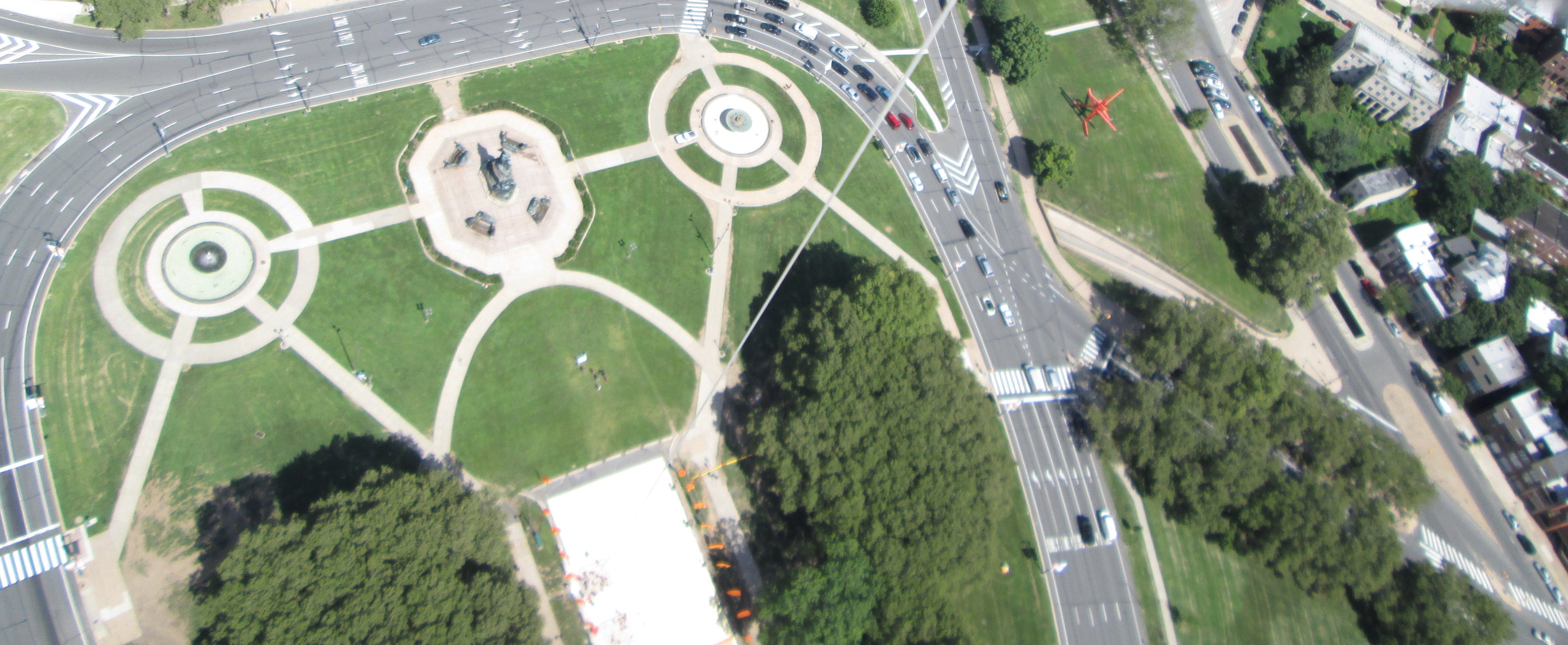
On a bright blue August day, geographers Dana Bauer, Michelle Schmitt, Megan Heckert, and student Megan Brock flew a five-foot wide red balloon about 500 feet above The Oval. Below the balloon they rigged a camera, set to take photographs every few seconds, held steady in a cheapo housing built from cut up plastic juice bottles. Alongside the thousands of aerial photographs, the geographers conducted more traditional surveys of activities and people in The Oval every half-hour.
The result was thousands of photographs of The Oval as a complement to data from an on-the-ground survey.
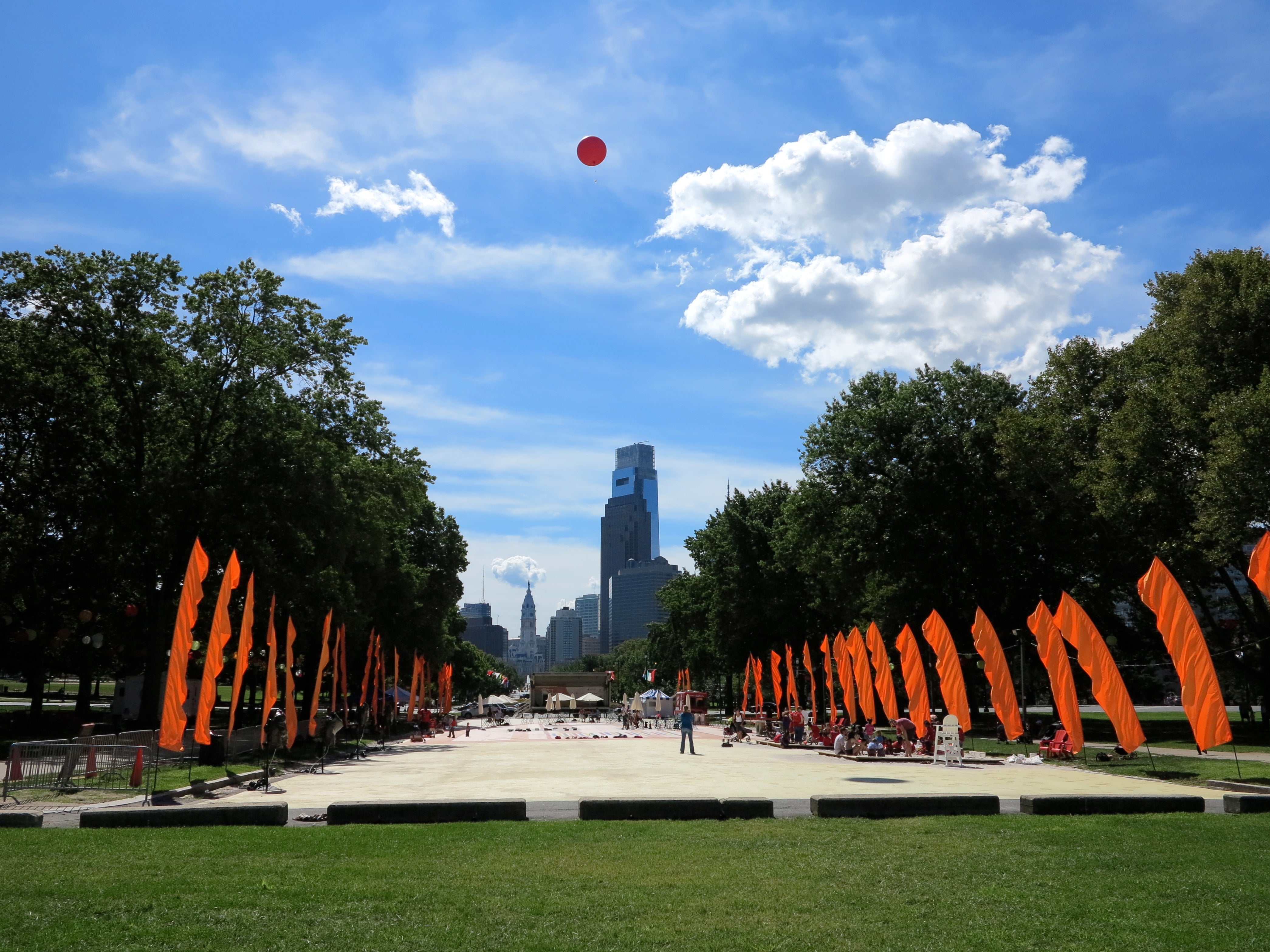
It’s pretty hard to miss a five-foot wide red balloon, and high-visibility is part of the point. The balloon itself is public expression of observation and a pretty non-threatening way to collect information and invite people into conversations about mapping and their environment.
“The data is public but the process is also very public and open,” Bauer said.
And sure enough every time the balloon went up and down people stopped to ask just what these women were doing with that big red balloon.
-

Geographer Dana Bauer letting a camper visiting The Oval hold the kite string. -

Dana Bauer and Swarthmore intern Megan Brock getting ready to send the balloon up again.
The experiment at The Oval was done as part of The Public Lab, a DIY environmental science organization that provides people with low-tech tools and strategies for conducting their own research about their communities in very public, transparent ways.
Citizen groups typically use The Public Lab’s balloon mapping technique to collect environmental data. (It was extensively used after the BP oil spill in the Gulf of Mexico during the media blackout, for example.) But balloon mapping has not been deployed to gather data about public spaces as often. Still, it could be a powerful tool for civic research forjust about anyone with access to the basic materials.
This kind of aerial observation isn’t especially new but the method is. It’s not far afield from William “Holly” Whyte’s famed 1980 study about how people use New York’s small urban public spaces, geared at understanding why some places work remarkably well and others flop. Whyte’s clandestine films of people’s behavior in public parks and plazas, and his observations – like our collective preference for movable furniture and people watching – still profoundly influence the design of public spaces we see cropping up in cities.
So what might we learn from the pop-up craze through balloon mapping (or some other means) about our current public space preferences?
Design interventions, like the summertime programming at Eakins Oval, change how people use public spaces. If the city or private groups are willing to make modest investments geared at improving the life of our public spaces, it’s worth studying just how people respond to those changes to be sure scarse funds are spent effectively.
“We don’t know what works and why,” Schmitt said. “If we’re seeking to redesign a public space let’s do it in a way that’s public.”
-

Balloon Mapping Quick Start Guide -

Dana Bauer and Michelle Schmitt at their informational table in the shadow of the balloon. -

Is this thing on? Dana Bauer checking the digital camera, holding its hacked juice-bottle-rig.
Following their fieldwork, Schmitt said they combed through the thousands of images and selected hundreds that they can use to create a basemap of The Oval. They hope to post that map on The Public Lab’s website at the end of this month.
“The biggest lesson of the day is that we need to capture more images from a lower altitude,” Schmitt said over email. “Most of our images were from several hundred feet up…These photos were taken from just too high up to capture the details of human activity that we are after. We were able to capture some images better suited to analyzing public space usage at lower altitudes. These were very promising, but we didn’t get as many of them as we would like.”
For future projects, Schmitt thinks they may use a combination of balloon mapping aerials and extension-pole photos like those used for sports photography to get at a finer level of detail.
WHYY is your source for fact-based, in-depth journalism and information. As a nonprofit organization, we rely on financial support from readers like you. Please give today.
Brought to you by PlanPhilly

PlanPhilly
In-depth, original reporting on housing, transportation, and development.
Part of the series

Eyes on the Street
Eyes on the Street brings new ideas and fresh voices into the conversation about Philadelphia’s changing cityscape.
