Snow for South Jersey tonight

The northwestern fringe of a storm that will pass well offshore is expected to deliver light snow to South Jersey tonight and early Wednesday morning.
Forecasters have been monitoring the threat since last Friday, when one forecast model indicated a glancing blow to southern portions of New Jersey. But beginning Sunday, more forecast models began converging on a northwest trend, increasing snow chances, especially in southeastern areas.
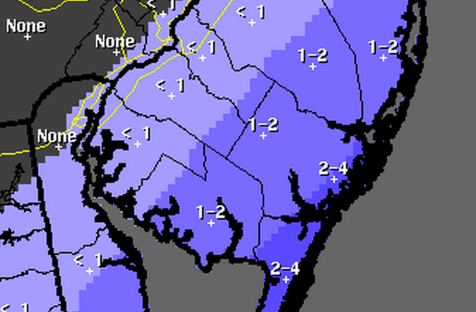
A total snowfall accumulation map issued by the National Weather Service office in Mount Holly, NJ Tuesday morning depicts the heaviest snow in Cape May County and coastal Atlantic County (2-4″), with lesser amounts to the north and west (1-2″). The snow shield extends to the NJ Turnpike, where areas to the immediate south and east of the highway could see an inch or less.
“Snow should overspread the area generally from south to north early this evening, then taper off toward daybreak Wednesday,” a Winter Weather Advisory for Cape May and Atlantic counties advises. “Roads will become snow covered and slippery due to temperatures well below freezing and accumulating snow. Travel conditions will become hazardous.”
Forecasters could bump the Winter Weather Advisory further north and west later today if model guidance continues the northwestern storm progression.
WHYY is your source for fact-based, in-depth journalism and information. As a nonprofit organization, we rely on financial support from readers like you. Please give today.

