Philadelphia’s ever-changing right of way, adapting to the needs of users
If you look at historic photos of Philadelphia, you will notice how the street is used differently. Today's planners must design for the needs of users, and anticipate trends.

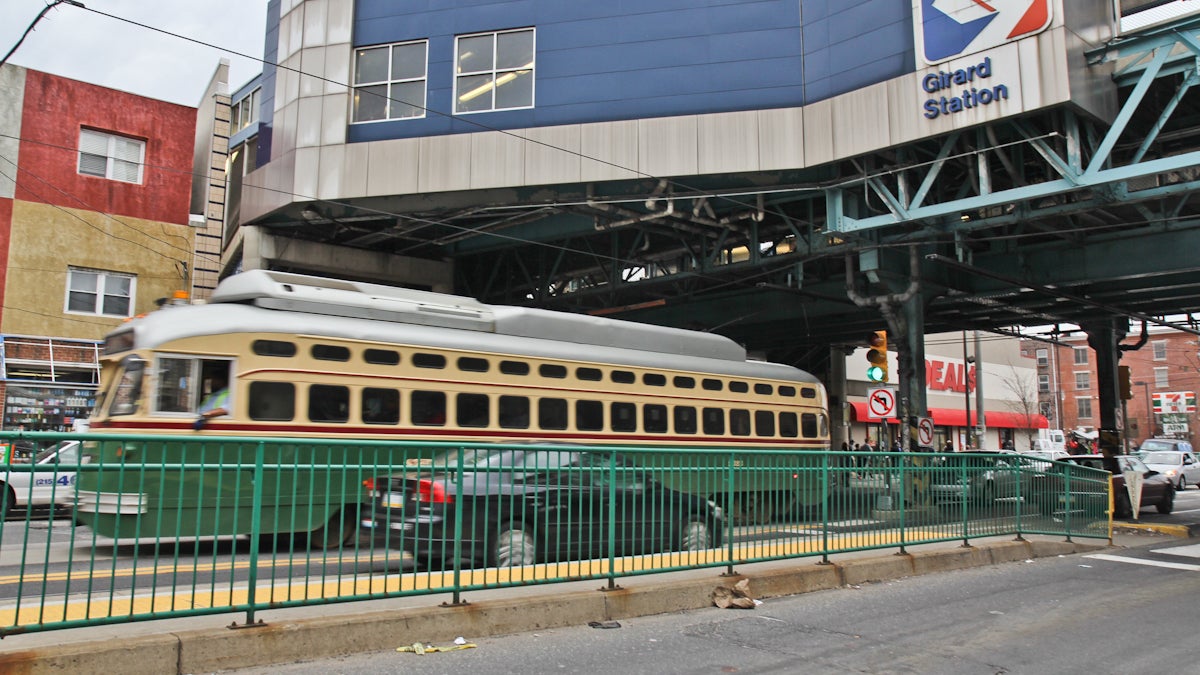
A trolley runs down Girard Street under the Girard Street station of the Market-Frankford Line. (Kimberly Paynter/WHYY)
Speak Easy is examining issues of street use in Philadelphia. What should our priorities be to ensure safe streets for pedestrians, bicyclists, motorists and transit users? Seeking diverse perspectives on these issues, NewsWorks is hosting a public forum, “Philadelphia Streets Under Pressure,” on June 30 at WHYY studios. Registration is free at whyy.org/speakeasy.
—
If you look at historic photos of Philadelphia, not only are the buildings and skyline very different from today, but you will also notice how the street is used differently. Today’s designers must recognize these changing trends, design for the needs of the various users, and anticipate future trends. How did we get to this point and how do we get to the next level?
Over 300 years ago, William Penn created the original City Plan. He envisioned Market Street and Broad Street to be multi-use streets and made them 100 feet wide, more than twice as wide as other streets. He also included five public squares for green space. Penn was planning not just for capacity but also how the spaces could be used.
In the ’60s and ’70s, designers concentrated on more lanes, more capacity, and higher speeds. Designs were based on numbers; and the needs of the users, human behavior and how people could “experience” the street were not considered. We looked at future capacity, not future use. A result of this thinking was I-95 creating a barrier cutting off Philadelphia from the waterfront.
Listen to needs
Today, we have not only more users than ever but also a greater variety of users — but there is no more room to widen the right of way. Now we have to start thinking about smarter, more efficient use of the right of way in order to accommodate all users.
Where do we start? How can today’s designers determine and evaluate the needs of the users for a transportation project? All we have to do is listen and understand. Listening is easy. As the chief engineer for the Philadelphia Department of Streets, everywhere I turn, I am told by someone about what I should be incorporating into my projects. Over the past 30 years, advocacy groups and community organizations have found their voice and begun to educate the politicians and designers on the needs of the various users. These groups are a wealth of information and ideas. You just have to have an open mind and put your own opinions aside for a few minutes.
Have you ever ridden a bike three feet away from cars going 50 mph? Have you ever walked to work with your eyes closed? Crossed the street in a wheelchair? Driven a tractor trailer? Very few of us can say we truly understand the needs of all the users, so when we are listening with an open mind we have to imagine ourselves as the other users. Then we begin to understand that it is not just numbers but perception.
Take human behavior into account
When we narrow the travel lanes, vehicles drive slower. A few trees and well placed street furniture make a sidewalk more inviting to walk down and stimulate commerce. Sidewalk cafés are another new user to the right of way, enhancing the experience but also requiring some precious sidewalk width.
Dividing the sidewalk into zones helps us to allocate this space. We now look at the sidewalk as three zones: the furniture zone against the curb that creates a buffer, the walking zone, and the building zone against the buildings. The width of each of these zones varies depending on the use of the street and the volume of pedestrians.
Todays designers have to take this all in and recognize that each location is unique and requires a separate evaluation of the users’ needs, because there is just not enough room to accommodate everyone. Tough decisions must be made in allocating space to different users. As my office develops project plans, we get input from a variety of community groups, business groups, advocates, and planners in order to see the big picture. Armed with this information we are better able to find the right balance at each location for successful projects that can stand the test of time.
To assist designers and developers, the City has developed the Complete Streets Handbook as a guide to help designers understand the needs of the users. The handbook is a tool, not an instruction manual. Engineers and designers must evaluate each location to see how it is and could be used to determine the best allocation of space to the users.
—
Darin L Gatti is the chief engineer and surveyor of the Philadelphia Streets Dept.
WHYY is your source for fact-based, in-depth journalism and information. As a nonprofit organization, we rely on financial support from readers like you. Please give today.


