NWS: Mostly “low confidence” on potential Matthew impacts this weekend

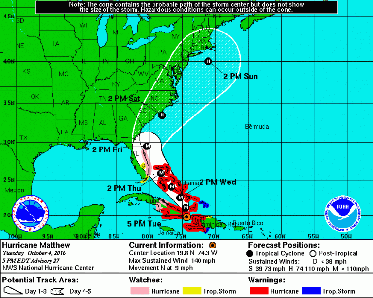
The National Hurricane Center's 5 p.m. update.
The local National Weather Service says there’s “low confidence” for a number of potential impacts in the New Jersey region from Hurricane Matthew later this weekend.
“There is a great deal of uncertainty as to the track Matthew will take this weekend,” meteorologist Joseph Miketta of the NWS office in Mount Holly, NJ wrote in a briefing issued this afternoon.
As of 5 p.m. today, Hurricane Matthew is a Category 4 hurricane situated between Cuba and Haiti with maximum sustained winds of 140 mph. Here’s the forecast map.
The cyclone is then expected to continue as a major hurricane through the Bahamas on Thursday and then potentially making landfall along the eastern Florida coast by Friday morning.
But that’s where the certainties end. That’s why the National Weather Service is taking a careful approach in conveying information to the public.
“If the storm takes more of a westerly track, and is closer to the coast, it would result in impacts that would spread farther inland, with the potential for significant impacts along the coast,” Miketta wrote. “However, if the storm takes more of an easterly track as it approaches the Carolinas and curves out to sea, then the impacts for at least western portions of the forecast would be mitigated, with limited impacts, mainly along the coast and over the waters.”
The briefing notes that the current forecast is mainly “low confidence” for now, except for rip currents:
Strong Winds: Low confidence. If the storm tracks close enough to our coast, tropical storm force winds could develop near the DE and southern NJ coast possibly as early as Saturday afternoon, and could last into Sunday evening. The strongest winds will most likely occur Saturday night into Sunday morning.
Heavy rain: Low Confidence. The first bands of rain could spread into the area by Saturday morning. Depending on the track Matthew takes, heavy rain could then impact the area Saturday night and Sunday. There will likely be a sharp gradient between no rain to the west and very heavy rain to the south and east. Therefore, even subtle shifts in the track could result in widely different rainfall amounts. A track closer to the coast could result in excessive rainfall in a 12- hour period that would lead to flooding. Areas in the Delmarva and far southern NJ that received heavy rainfall last week would be most prone to flooding.
Storm surge: Low Confidence. A persistent onshore flow may develop ahead of Matthew that could result in a buildup of water along the NJ and DE shores. We are in between moon phases, so astronomical tides will be low. It is too soon to determine the extent of the tidal flooding which will be highly dependent on Matthew’s track. Based on the current track, there is a potential for at least minor to moderate tidal flooding this weekend.
Rip Currents: High Confidence. With the approach and passage of Hurricane Matthew, longperiod swells will build along the coast, providing in a high risk for the development of dangerous rip currents. Beach erosion is also possible.
The National Hurricane Center echoes the uncertainty for our region:
“It is too soon to specify what, if any, direct impacts Matthew might have on the remainder of the U.S. east coast farther north. At a minimum, very dangerous beach and boating conditions are likely along much of the U.S. east coast later this week and weekend.”
WHYY is your source for fact-based, in-depth journalism and information. As a nonprofit organization, we rely on financial support from readers like you. Please give today.

