

Nor’easter to bring heavy snow, rain, wind and flood threats to Delaware Valley
We know a nor'easter is headed toward the Philadelphia region — but it also looks like its impacts could vary greatly from neighborhood to neighborhood.
This story originally appeared on NBC10.
___
From the Lehigh Valley to the Jersey Shore, a major winter storm is expected to have very different impacts as it roars through the Philadelphia region Wednesday into Thursday. Some areas could get around a foot of snow while other areas see heavy rain and a flooding threat.
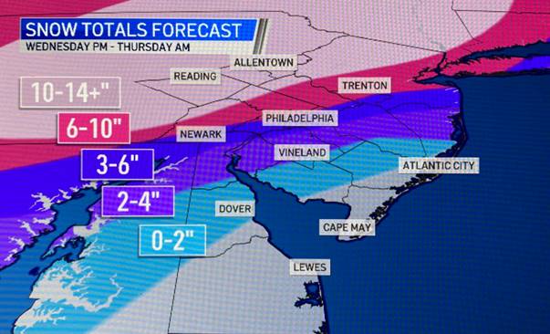
The NBC10 First Alert Weather Team has issued a FIRST ALERT for heavy snow, heavy rain, strong winds, and coastal flooding for the area from Wednesday afternoon through Thursday morning due to a high impact nor’easter. A winter storm warning is in effect for all Pennsylvania counties in the region.
The storm will begin Wednesday afternoon and is expected to peak Wednesday evening through the early overnight hours Thursday. Then it tapers off Thursday morning with snow showers as heavy wind gusts could cause power outages.
The further you are from the coast, the more snow that is expected. Some neighborhoods to the north and west could get around a foot of snow while barely any snow falls along the Jersey Shore. Notice how thin the snow total lines are between several inches of snow and only a couple of inches.
Tuesday is a good day to clean out gutters and drains and make any other preps needed before the storm as conditions will remain clear through the day.
Below are impacts for each of our neighborhoods from this storm. Please check back to future forecasts every few hours as a slight change in track could mean MAJOR adjustments to snow totals, wind speeds, etc. This is an evolving situation. Changes in track are completely normal and to be expected with storms like this one.
Berks Co., Lehigh Valley, Distant Pennsylvania Suburbs (Upper Bucks, Montgomery and Chester counties)
The biggest impact from this storm will be heavy snow. Snowfall accumulations of 10 inches or more are expected with some locations picking up over a foot. There will be some blowing and drifting of snow, but it shouldn’t be severe as winds in this area won’t be as strong. Expect road conditions to become impassible at times Wednesday evening and night with intense snowfall rates. Expect poor driving conditions Wednesday afternoon through Thursday morning.
Immediate Suburbs (upper Delaware, lower Montgomery, lower Bucks and Mercer (NJ) counties)
Expect heavy snow, sleet, freezing rain, and rain. This area has a high uncertainty of potential snowfall totals due to sleet and/or rain mixing in during the height of the storm. Right now, the most likely results for this area is 6 to 10 inches of snowfall with sleet, freezing rain, and rain mixed in with the snow.
However, a slight shift in the storm track north or south would dramatically change the amount of snow for these neighborhoods.
Related Content

Isaias poured floodwaters on the Heinz Refuge in August. It’s been rising above them since
Rain from Tropical Storm Isaias sent Darby Creek overflowing. More than 3 months and a major restoration effort later, things are almost the way they were.
6 years ago
Listen 1:19Philadelphia, northernmost Delaware, Delaware County and parts of South Jersey
Three to 6 inches of snow is expected in Philadelphia and its immediate neighborhoods, but a slight change in the storm’s track could change this total either way. Sleet and/or rain could mix in during the storm as well, lessening snow totals.
Expect slippery road conditions during the height of the storm.
Interior South Jersey to north-central Delaware
The storm will start as snow early Wednesday afternoon, but quickly change to rain. The majority of the storm will be heavy windswept rain. There is a chance for up to 4 inches of wet snow toward the end of the storm as cold air arrives.
Jersey Shore and Delaware Beaches
Heavy, windswept rain is expected for shore communities Wednesday afternoon through Wednesday night. One to two inches of rain is possible with localized areas of street and highway flooding. Heavy rainfall may combine with tidal inundation during high tide to cause coastal flooding. Wind gusts of 50 to 55 mph are possible with power outages and localized wind damage. The rain will briefly change to snow early Thursday morning before ending. Little to no accumulation is expected.
Stay ahead of the storm by downloading the NBC10 app now for the latest First Alert Weather forecasts.
Never miss a moment with the WHYY Listen App!
WHYY is your source for fact-based, in-depth journalism and information. As a nonprofit organization, we rely on financial support from readers like you. Please give today.

Philadelphia snow updates: City emergency lifted; 3 die while shoveling in Pa.; latest storm impact
Bitter temps will linger across Pennsylvania, New Jersey and Delaware this week. Here’s everything you need to know.
6 months ago

Photos: Snow blankets the Philadelphia region in first major storm of 2026
Here's how the winter storm and its aftermath have unfolded, in photos.
6 months ago

Icy conditions remain after heavy, wet snow hits Philly region
A final band of snow is moving out of Philadelphia, the suburbs, Lehigh Valley and central New Jersey Thursday morning.
6 years ago