

#Jonas is a whopper in New Jersey [photos]

-

-

-

-

-

-

-

-

-

Jonas from above (Photo by International Space Station Commander Scott Kelly)
-

-

-

-

-

-

-

The powerful winter storm hitting the East Coast today isn’t over. Forecasters expect additional snowfall through the night tapering off Sunday morning.
The National Weather Service said this afternoon it was raising the snow projections for New Jersey.
Snowfall will continue through the day…with rain along the coast. As cold air moves back into the area later today…rain along the coast will turn back to snow. Another 7 to 12 inches in addition to what has already fallen is expected today around Philadelphia, northern Delmarva, and central New Jersey. Another 12 to 20 inches in addition to what has already fallen is possible near and to the north of I-78.
Snow totals as of 1/24/16 at 5:42 a.m.
Please click through the photo gallery above. It is a carefully curated collection of some of the most dramatic photos of the 2016 Jonas storm in New Jersey.
Most areas of Central and Southern New Jersey have reached 12 or more inches of snow as of noon today. The most dramatic footage though is coming from New Jersey’s coastal towns like Ocean City, Sea Isle City and Cape May where widespread street flooding could be seen after this morning’s high tide.
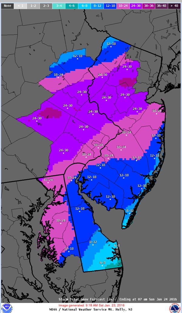
Total snow projections for Fri, Sat and Sun
During a 12 noon news briefing from Sayreville, NJ., Governor Christie said as far as flooding goes things should improve. “That water is receding and information we’re getting from the National Weather Service is that the high tide tonight will be less significant than the one this morning and the one tomorrow morning will be even less significant than that. So for the folks down in Cape May County you’re probably in as bad as shape as you’re going to be. It will get better as the day goes on,” Christie said.
Christie also said that while this is a bad storm it isn’t as bad as some people are saying. “Try not to buy into some of the hyper talk that goes on at times around this stuff. if you stay in side and stay warm you’re going to be fine.”
Earlier on Saturday utility companies in New Jersey reported that nearly 100,000 customers were without power. Late this afternoon that number was down to 58,000, with the majority of those affected in central and southern areas.
Jersey Central Power & Light says about 27,000 customers were without power Saturday night, with outages along the coast from north of Sea Bright south to near Barnegat Light. The outages come as a strong winter storm packing high wind and snow moves through New Jersey.
Atlantic City Electric reports roughly 30,500 customers without power. The outages stretch from Barnegat Beach south to Cape May and as far west as Mantua.
The New Jersey State Patrol said at 1:25 p.m. that so far there have been 222 car accidents during the storm.
Gov. Chris Christie said the state of emergency issued last night remains in effect until further notice.
WHYY is your source for fact-based, in-depth journalism and information. As a nonprofit organization, we rely on financial support from readers like you. Please give today.

Former Wildwood mayor accused of official misconduct, tax evasion in new 7-count indictment
According to the N.J. Attorney General's Office, Pete Byron abused his position to request a job from a city attorney, then failed to pay state taxes on that job's earnings.
7 hours ago

Pa., N.J. to receive millions for solar energy projects that will benefit residents with low income
The solar projects will lower energy bills for overburdened residents of the Philadelphia region, federal officials say.
17 hours ago

‘A chance to tell their own stories’: New documentary tackles environmental racism in Camden
In a documentary premiering Monday, Rutgers-Camden students spotlight the environmental issues faced by residents of the city.
19 hours ago