Cooler than normal temperatures, severe storms possible next week

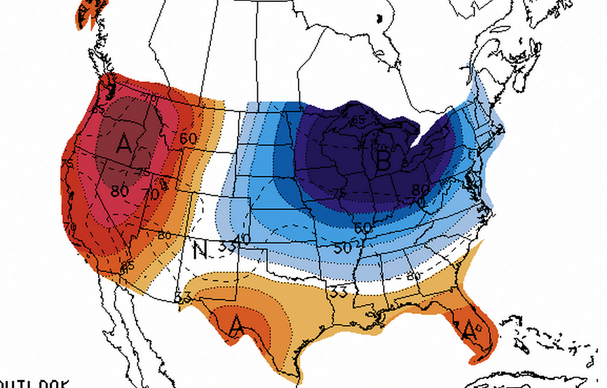
A National Weather Service Climate Prediction Center graphic showing a moderate chance of below normal temperatures in New Jersey between July 15 and July 19.
The polar vortex — the frigid pocket of Canadian air that dropped down into the United States this winter and quickly became a media sensation — is returning for a summer vacation.
It’s due to a “massive upper level troughing system, which will feature much below normal temperatures both aloft and at the surface,” said John Homenuk, lead forecaster at New York Metro Weather, who dubs the summer redux the “Not-So-Polar” Vortex.
“The track, size and orientation of the system bear many resemblances to the Polar Vortex which tracked through the Great Lakes this past January,” he said.
But this time, we won’t be shivering. So what does it really mean for New Jersey?
There’s a 40 to 50 percent chance that temperatures will be below normal between July 15 and July 19, according to the National Weather Service Climate Prediction Center. High temperatures could be in the 70s. In the northern Midwest, the chance of below normal temperatures is much greater.
“The ‘Not-So-Polar’ Vortex won’t ever take a massive grip on the Northeast US, as it will elongate and slide to our northwest, owing to the Western Atlantic Ridge,” Homenuk said.
But with the cold and warm air contrast, there’s a potential for severe weather next week, he cautioned.
WHYY is your source for fact-based, in-depth journalism and information. As a nonprofit organization, we rely on financial support from readers like you. Please give today.

