What’s upcoming on the weather front? Snow threats “far from over,” forecasters say

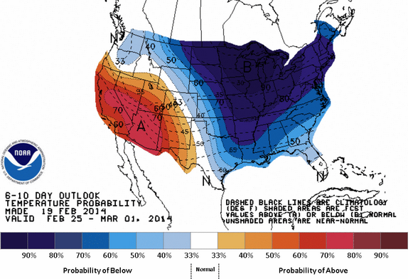
The 6-10 day temperatures probability outlook issued by the National Weather Service Climate Prediction Center, indicating a high probability of below normal temperatures between February 25 and March 1.
One thing is certain: we are now in what forecasters call a “transient” weather pattern. But where we’re heading will not make those who are desperately hoping for an early spring pleased.
Compared with the recent cold and stormy weeks, temperatures through this weekend will be downright tropical.
High temperatures will remain above freezing, with readings in the 40s throughout the New Jersey region Thursday, according to the National Weather Service. On Friday, many locations will be in the 50s, but it will be a stormy day, with showers and potentially thunderstorms moving through the region during the afternoon. Then on the weekend, it will be pleasant and seasonably warm.
But don’t let it fool you.
Throughout the winter, the beginning of the next cold outbreak has been visible as the brief warmer periods invade, according to New York Metro Weather forecasters.
“And so the coming 10-day period is a microcosm of our winter’s progression to date, one which featured strong polar/arctic outbreaks interspersed with sharp yet temporary spells of mild weather,” New York Metro Weather forecasters wrote in a long term discussion Wednesday evening.
In short, winter’s returning.
Here’s what New York Metro Weather says to expect over the coming weeks:
An arctic outbreak arrives by early week, with temperatures much colder than normal for the last three to four days of February.
A storm threat for Wednesday, February 26. Details are currently uncertain.
Another storm threat for Friday, February 28 and Saturday, March 1. Details are uncertain this far in advance.
A colder than normal March pattern is possible.
And the kicker: Snow threats are far from over for this winter season. Records of the top three snowiest winters could be in reach for New York City.
So enjoy the warm weather while it lasts, then buckle up as winter returns with a vengeance.
WHYY is your source for fact-based, in-depth journalism and information. As a nonprofit organization, we rely on financial support from readers like you. Please give today.

