Weekend storm to deliver a variety of wintry weather impacts

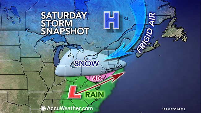
AccuWeather.com's current forecast depiction.
A winter storm will move through the New Jersey region this weekend, and forecasters say it will deliver a mixture of wintry weather impacts.
But with the storm still about 48 hours away, the details will become fine tuned and may change while the system is moving through the area.
“This storm is going to be something to watch here,” advises NY NJ PA Weather meteorologist Steven DiMartino in his latest video forecast discussion, noting that depending on how a high pressure system to the north behaves, the changeover to rain along the coast will take longer “than some of the model guidance is showing.”
New York Metro Weather meteorologist John Homenuk echos DiMartino’s analysis in his organization’s latest briefing on the system.
“So while forecast models are starting to come into better agreement on the system, slight waffles in the forecast track keep our confidence fairly low. Second, precipitation type — owing to temperatures and atmospheric profiles before and during the event. In situations like this one, where a few degrees can make a world of difference as far as sleet, snow, and freezing rain are concerned — confidence will remain very low. In this regard, confidence will not be high until the day of the event as we track mesoscale developments in temperature,” Homenuk says.
The National Weather Service office in Mount Holly, NJ has issued a briefing package on the impeding storm, breaking down the threat into three components: timing, precipitation type, and tidal flooding.
TIMING
Precipitation will begin early Saturday morning and end Sunday morning. Precipitation could begin as all snow almost everywhere, but as warmer air begins to move in, a changeover to sleet, freezing rain, then plain rain is expected from south to north. However, precipitation may remain as snow or a snow/sleet/freezing rain mixture north of the I-78 corridor throughout the event.
PRECIPITATION TYPE
More details concerning snow / ice accumulations will be available as we get closer to the event.
The National Weather Service has issued probability maps for snow and ice accumulations. Based on the mapping, the best odds (40 to 50 percent) for snow accumulations are for Central Jersey northward, with the highest likelihood of more than four inches of snow in northwestern sections of the state. Ice accumulations are also possible, with the best odds in the same areas.
TIDAL FLOODING
A full moon occurs on December 17th (next Tuesday). However, because this storm will be moving fast enough, tidal flooding, if it develops at all, should be minor.
In summary, according to the local National Weather Service office, here’s a quick list of what to expect (valid as of Thursday morning):
A variety of precipitation; most of frozen/freezing precipitation north and west of I-95.
High confidence that the event will occur, but lesser confidence with actual amounts and precipitation types.
Two to five inches of snow from I-95 to the north and west, with the greatest amounts in the Poconos. Ice accumulations of a tenth of an inch or less.
Precipitation tapers off early Sunday as the system departs.
Stay tuned as more information becomes available.
WHYY is your source for fact-based, in-depth journalism and information. As a nonprofit organization, we rely on financial support from readers like you. Please give today.

