Tropical Storm Watch issued for the Jersey Shore

The National Weather Service has issued a Tropical Storm Watch for the Jersey Shore.
According to the National Weather Service, a Tropical Storm Watch means that “sustained winds of 34 to 63 knots (39 to 73 mph or 63 to 118 km/hr) are possible within the specified area within 48 hours in association with a tropical, subtropical, or post-tropical cyclone.”
A Tropical Storm Warning indicates that the same conditions are expected within 36 hours.
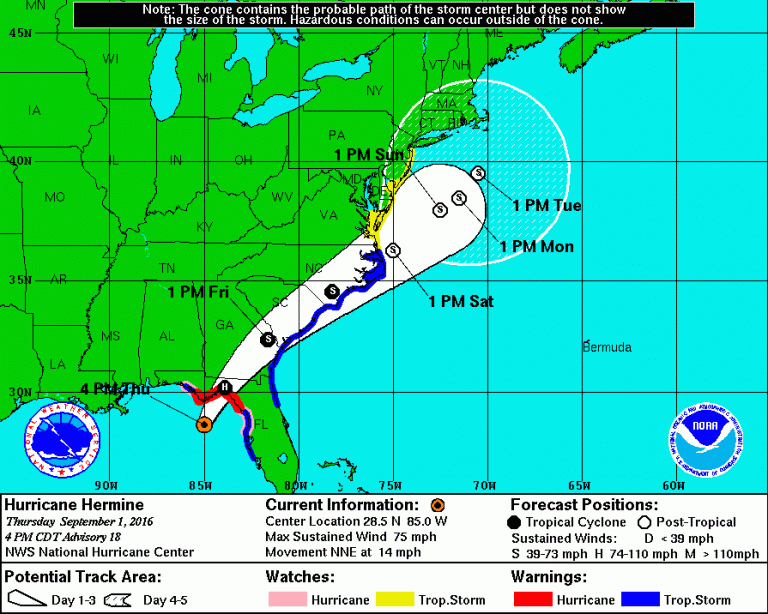
The latest National Hurricane Center forecast as of 4 p.m. today is in the image above. New Jersey remains within the National Hurricane Center’s “cone of uncertainty” for potential impacts from Hermine, a minimal hurricane scheduled to make landfall along the northwestern Florida panhandle early tomorrow morning.
Global forecast models continue to wobble with the system’s track when it arrives in the region by later Saturday as a post-tropical system — meaning that it no longer will have tropical storm status but can still produce multiple hazards — so it’s important to continue paying attention to subsequent National Weather Service/National Hurricane Center forecasts.
Stay tuned for additional updates tonight from Jersey Shore Hurricane News (JSHN) and here.
Also be sure to read JSHN’s important comprehensive storm updates from earlier this afternoon, available here and here.
WHYY is your source for fact-based, in-depth journalism and information. As a nonprofit organization, we rely on financial support from readers like you. Please give today.

