

Tropical Storm Hermine gaining strength but moves further away from the coast


Hermine is nearing hurricane strength again, as it moves away from the mid-Atlantic coast.
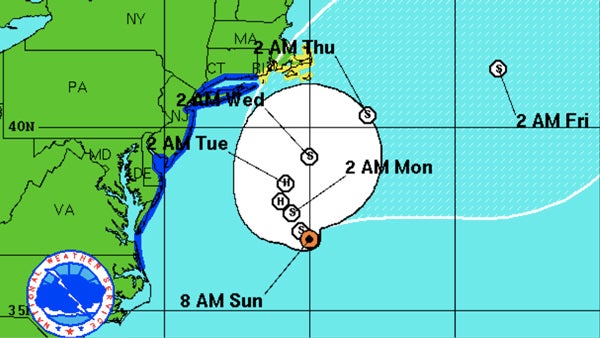
Maximum sustained winds are near 70 mph (110 km/h) with higher gusts. Hermine should remain at or near hurricane strength for the next day or so, and begin to gradually weaken by Monday night.
As the storm moves east it means the chance for heavy rain has dropped considerably but the ocean waters continue to be dangerous with favorable conditions for rip currents. For ocean front areas in Delaware and Southern New Jersey the main concern is now the storm surge that could raise the water level by 2 -4 feet. The rough waters are causing beach erosion and will likely result in back bay flooding during the Sunday night and Monday morning high tide cycles.
The National Hurricane Center says Hermine’s winds are now up to 70 miles per hour. At 11 a.m., Sunday, September 4, 2016., the post-tropical cyclone was centered about 300 miles east of Ocean City, Maryland, moving toward the east-northeast at 10 mph.
A Tropical Storm Warning remains in effect in New Jersey for the following counties:
Atlantic
Atlantic Coastal Cape May
Cape May
Coastal Atlantic
Coastal Ocean
Eastern Essex
Eastern Monmouth
Eastern Union
Hudson
Middlesex
Ocean
Southeastern Burlington
Western Monmouth
New Jersey officials and utility companies continue to keep a close eye on Hermine and the potential damage the storm system could cause along the Jersey shore. New Jersey Gov. Chris Christie warned today some areas could still experience problems. “Don’t be lulled by the nice weather,” Christie said, referring to the bright sunny skies along the Jersey Shore on Sunday. “Don’t think that nothing is going to happen, because something is going to happen.”
A Tropical Storm Warning remains in effect for the following counties and areas in Delaware:
New Castle
Kent
Inland Sussex
Delaware beaches
The City of Rehoboth Beach says that the beach is closed to foot traffic and swimming prohibited. Jim Derrick, a business owner in the Rehoboth area says that street traffic is lighter than usual. Derrick said by phone that the main road was “a little stop and go” traffic when “this weekend would normally be a parking lot.”
The National Weather Service says areas under the warnings can expect winds 25-40 mph with some gusts near 50 mph. Peak storm surge waters could be 2-4 feet higher than normal.
The National Weather Service says conditions are UNFAVORABLE for any tornadoes.
Since it moved ashore along Florida’s northern Gulf coast early Friday, Hermine has already caused two deaths, damaged properties and left hundreds of thousands without electricity from Florida to Virginia.
The Associated Press contributed to this report
WHYY is your source for fact-based, in-depth journalism and information. As a nonprofit organization, we rely on financial support from readers like you. Please give today.

City of Camden issues cease operations order to EMR after two-alarm fire
The order comes after city, county and state elected officials called on government agencies to shut EMR’s Camden operations.
10 hours ago

Angelina Katsanis was on assignment for The Associated Press on Saturday night when she was struck in the knee by a wood beam during a clash between police and protesters.
15 hours ago

Open water presents risks that pools don't. A New Jersey swim coach explains how to handle currents, waves and other hazards.
15 hours ago
Listen 6:23