Irene closes in on Cape May; waters on the rise
-
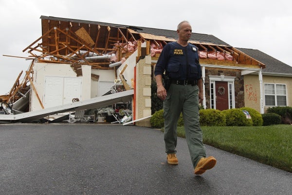
A member of the Delaware State Police walks away from a house that was heavily damaged by a possible tornado in Lewes, Del., Sunday, Aug. 28, 2011, after Hurricane Irene churned along the Delaware coast overnight. (AP Photo/Patrick Semansky)
-
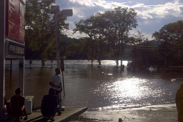
Sun hits the standing water on Kelly Drive in Philadelphia Sunday after stormed moved through the area. (Brian Hickey/For NewsWorks)
-
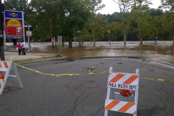
Flood waters creeped up towards a gas station in northwest Philadelphia Sunday. (Brian Hickey/For NewsWorks)
-

Pennsylvania Governor Tom Corbett stands alongside Philadelphia Mayor Michael Nutter after a press briefing Sunday in Philadelphia. (Brian Hickey/For NewsWorks)
-
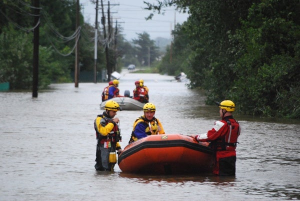
Teams went out in the swollen Christiana River Sunday looking for people who might be stranded from the flooding caused by Hurricane Irene. (John Jankowski/For Newsworks)
-
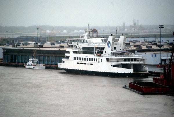
The predicted storm surge from Hurricane Irene forced the Cape May-Lewes ferry to head up the Delaware River and spend the night docked in Wilmington. (John Jankowski/for newsworks)
-
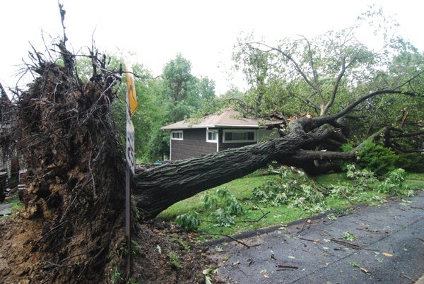
Heavy rains from Hurricane Irene uproot a tree in Edgemoor smashing into a home. (John Jankowski/For NewsWorks)
-
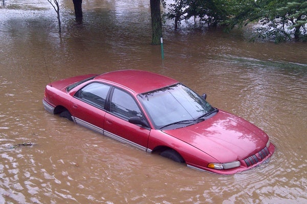
A car, stuck in flood water, was left abandoned without tages on East River Road. (Brian Hickey/For NewsWorks)
-
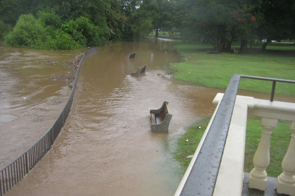
Hurricane Irene hits region.
-
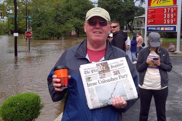
Sam Malloy, of East Falls, holds up a newspaper about Hurricane Irene. (Brian Hickey/For NewsWorks)
-
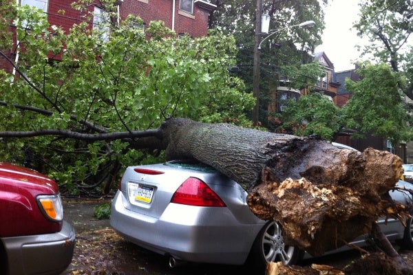
A large tree fell onto a car Saturday night as Hurricane Irene ripped through this Philadelphia nieghborhood, on the 4500 block of Osage Avenue. (John Meyers/For NewsWorks)
-
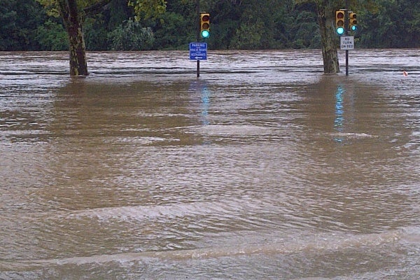
Flood waters crept up Midvale Avenue in northeast Philadelphia Sunday morning. (Brian Hickey/For NewsWorks)
-
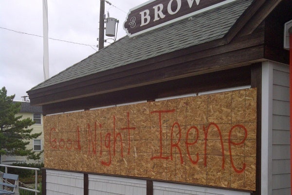
Some business owners in southern New Jersey got creative with the boards over their windows. (Tom MacDonald/For NewsWorks)
-
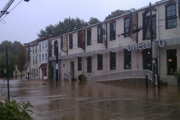
Flooding could be seen in Manayunk Sunday in front of this building at the intersection of Shurs and Main Street. (Megan Pinto/For NewsWorks)
-

Water flooded portions of this Philadelphia golf course on Lafayette Hill Sunday. (Chris Sattulo/For NewsWorks)
-
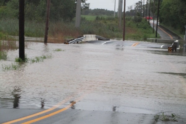
Dragon Run Creek over flows its banks and on to a local road near the Delaware City Refinery. (John Mussoni/for Newsworks)
-
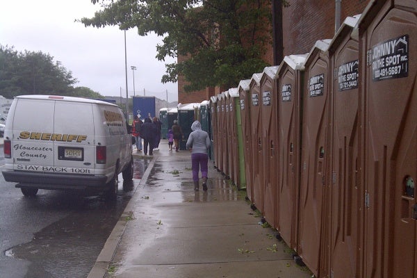
Things appeared calm outside one New Jersey shelter Sunday morning. (Tom MacDonald/For NewsWorks)
-
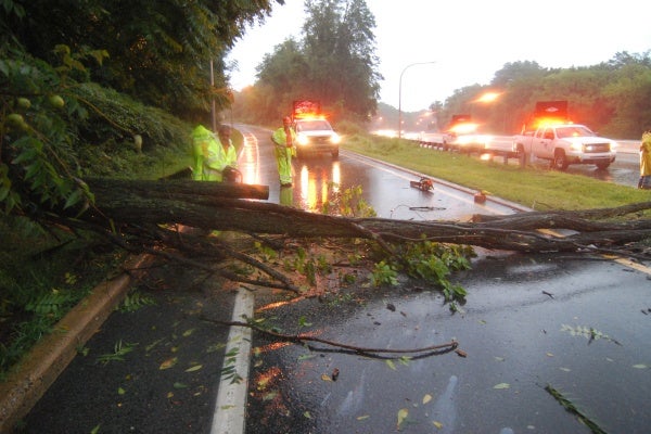
DelDOT crews work to remove a tree that had fallen at Route 202 southbound at the entrance to I-95 in Wilmington. (John Jankowski/for newsworks)
Winds are picking up as the heart of Irene nears the Philadelphia region. Later today, the Schuylkill River is expected to reach its highest crest since 1868.
Phillyweather.net says Irene is capable of spawning multiple thunderstorms. To view weather warnings for your area, visit National Weather Service and enter your zip code.
NewsWorks.org will continue to update you on the hurricane as it makes its way into our area throughout the weekend with updates from our reporters and news partners. Stay with us for complete coverage.
Update, 3:33 a.m. Irene is just off the coast of Cape May. Rain continues to drench the region, with flooding and widespread power outages reported. Winds are expected to intensify further.
Update, 2:00 a.m. From phillyWeather.net, Irene’s eye is now approaching Ocean City, MD and continuing to work northeast. The core of the storm is about to work into coastal Delaware and into Cape May, featuring wind gusts to near 80 mph as Irene’s center of lowest pressure lifts up the coast over the next several hours. The lull that you experienced earlier is shifting north into Central Jersey as another round of wind/rain return to Philadelphia — rainfall is picking up and will get heavier. However, the brunt of the storm over the next few hours will shift to the Delaware Beaches and the Shore. Winds locally will remain gusty but our strongest winds may still arrive when the eye passes east of us between 7 and 10 AM through the region. Wind gusts around DC reached 58 mph during the Midnight hour.
Update, 1:00 a.m. From NewsWorks’ weather blogger, phillyWeather.net: The “lull” that worked through Philadelphia is quickly ending, shifting into the northwest burbs and being replaced by another round of rain and wind sliding back into the city. This band is not, as of now, as bad for Philadelphia as the last round that is currently pivoting across the northern burbs and Central New Jersey. However, the shell of the eye of Irene is at the bottom of the radar below, located just offshore of the Virginia/Maryland border and sliding north-northeast. It’s generally on track to stay along the coast for the rest of the night.
Update, 12:54 p.m. WPVI-Channel 6 is reporting a confirmed tornado touchdown in Lewes, Del., with video of one house that might have been damaged by the twister.
Update, 11:30 p.m. From NewsWorks’ weather blogger, phillyWeather.net: The tornado threat is shifting slowly northward into Central Jersey and the northern suburbs as the band of heavy rain and wind grinds around Irene. Tornado warnings are out for Montgomeryville, Warminster, on down to Bensalem until 11:45. We’ll continue to see warnings issued off and on through the night, but the threat will gradually shift northward as this band shifts slowly north through Central Jersey. Tornado watches are out up into Metro New York as well as locally. In South Jersey, you’re getting a bit of a break from the wind and rain across Atlantic County and along the coast from LBI down to AC. This break will end when another feeder band from Irene works onshore over the next couple of hours.
Update, 10:28 p.m. A tornado warning has been issued for Philadelphia, from Center City toward the Northwest and King of Prussia, until 11 p.m. PhillyWeather.net puts the threat this way: “This band of rain working into the region means business and in hurricanes you can get spin up tornadoes with little or no warning.”
Update, 10:00 p.m. Mayor Michael Nutter anticipating 7 to 9 inches of rainfall, causing widespread flooding. The Schuylkill is expected to crest well above flood stage, at 15 feet, the highest since 1869.
He said 136 have reported to shelters so far.
As of midnight, he said, about 5,000 PECO customers were without power.He noted that the Delaware River Port Authority is banning motorcycles, trailers and high-profile vehicles from its bridges.
SEPTA has waived all fares until it shuts down around midnight. Bus detours are in effect in a variety of flooded areas.
There have been numerous reports of powerlines down around the city.
Update, 9:48 p.m. The National Weather Service as reported that a tornado was spotted on the ground in Vineland, moving rapidly southwest. Tornado warnings are popping up in Delaware and New Jersey.
Update, 9:25 p.m. Philadelphia International Airport anticipates closing tonight at 10:30 p.m. after the last scheduled airline departures, and will remain closed until at least 4:00 p.m. It was previously announced that there would be no scheduled departures for Sunday. Airport Management, in conjunction with City officials, will assess the situation throughout the day tomorrow and advise when the Airport will resume operations.
Update, 9:09 p.m. The latest from NewsWorks weather blogger, phillyWeather.net.
The threat of quick spin-up tornadoes in coastal sections of South Jersey and Delaware is such that it is not a bad idea for folks down there to hang out in a lower level of their home for the next few hours this evening and overnight as tornadoes could be quick to spin up. Tornado warnings have been out this evening in the southern half of Delaware as well as coastal Atlantic County. Some of these tornadoes can spin with little or no warning. While the tornadoes will be ‘weak’ in the scheme of what a twister can be like, they can still cause a fair bit of damage in localized spots.
Update, 8:42 p.m. PECO reports that scatter outages have begun appearing around the region. A NewsWorks reader reported an outage in Wissahickon, 19128. Keith Simon told us: “Good thing for laptop battery and mifi internet access with battery backup. Sprint Rocks!!!!”
Update, 8:25 p.m. On Friday, NewsWorks’ Elizabeth Fielder did a story on wedding plans that had been scrambled by Hurricane Irene. Tonight, she went to a wedding celebration of friends’ who insisted on braving the storm for their big day. The evening came to an abrupt end, as Lizz reports here:
Guess Philadelphia is serious about this “state of emergency” thing.
Around 7 p.m. police shutdown a wedding of two close friends that I was attending in Philadelphia, just minutes after the bride and groomcut the cake.
The ceremony was held in a small building at Bartram’s Garden in Southwest Philadelphia. After that, about 100 guests enjoyed drinks and hors d’oeuvres under heavy-duty event tents. Friends and family were in good spirits snacking on shrimp skewers, bread and cheese, etc, while little rivers of water flowed along the ground under the tents.
The DJ had just played a personal favorite, MIA’s “Paper Planes,” when a police officer (possibly a state trooper) walked up to the DJ and told him to cut the music. He did, gracefully, in the middle of the song, then made a final joke about having hoped to fit in a song for Irene. End of reception. The police officer told guests to go home right away and stay off the roads after that. The rain was heavy and it was windy.
After the policeman warned the DJ, the happy couple were quick to comply: hugging guests who left with party favors in hand.n, very few cars, and all businesses closed except one barber shop near 33rd and Spring Garden. (It had its front door wide open. Inside two men looked bored, but otherwise it was empty).
Update, 8:05 p.m. Tornado watch in effect until 5 a.m. on Sunday for coastal sections of Delaware and New Jersey. Southeastern Atlantic County had a tornado warning in effect until a few minutes after 9 p.m. For a map of the affected area, click here.
Update, 7:18 p.m. The latest from NewsWorks’ weather blogger, Tom Thunstrom of phillyweather.net:
Rainfall is quickly picking up in intensity across the region, with bands of rain continuing to spiral in from the Atlantic, increasing in intensity as the storm lifts up from the south. The city crossed the one inch barrier at 6 p.m. and is now at 1.45″ as of 7 p.m., with 2-3 inches of rain already common across Delaware and South Jersey (and more to come). The next six to eight hours will feature increasing rain and wind as the storm continues its trudging up the coast, with the highest rain impacts generally along and west of I-95, with the greatest wind impacts continuing to be across the coastal sections of Delaware and New Jersey. Highest wind gust so far was in Georgetown, Del., at 59 mph during the 6 p.m. hour.
Update, 6:09 p.m. Philadelphia Mayor Michael Nutter declared a state of emergency for the city, for the first time since 1986. For people in low-lying or flood-prone areas, the mayor urged residents to evacuate “right now!”
He noted that people who go to one of three Red Cross shelters set up in the city can take their pets.
Nutter said the Schuylkill will crest at 14.2 feet, its highest level since Hurricane Floyd in 1999. Flooding has already started along the Schuylkill Expressway and in the Cobbs Creek section. Floyd had been downgraded to tropical storm by the time it reach the Philadelphia region.
“You can anticipate signicant power outages,” the mayor said. “You may experience power outages for upwards of a week, to 10 days to two weeks.”
“Do not travel unless absolutely necessary,” he urged. Only essential personnel or emergency workers should be on the street, he said.
He told people to report any homeless people who are seen out on the streets.
The mayor asked people to check on shut-ins and the elderly.
The declaration gives police additional powers to regulate people’s movements and to require that businesses, such and bars and restaurants, be closed during the storm and its aftermath.
“We are trying to save lives and we don’t have any time for silliness,” he said.
“We can do this,” the mayor said. “The most important thing is that we save lives.”
Update, 5:58 p.m. Here’s the latest from Tom Thunstrom of Phillyweather.net: Philly’s picked up over a half inch of rain the past three hours from Irene, now at 0.76″ of rain for the storm so far. Obviously, more to come. Georgetown, Del., is up to 2.77″ and Atlantic City is at 1.15″ so far through 5 p.m. A heavy band of rain is currently over the city, with another heavy band lurking about 20-30 miles southeast that will pivot in over the next couple of hours. Rain will gradually increase in intensity over the evening, with the worst of the rain/wind coming on later tonight and early tomorrow morning locally. Ocean City, Md., had a wind gust to 49 mph in the last hour.
Update, 5:40 p.m. The Delaware Department of Transportation (DelDOT) has closed three more bridges as of 10 p.m.: the Reedy Point Bridge at Route 9, the St. Georges Bridge, and the Roth Memorial Bridge on S.R.. 1 DelDOT will keep the Summit Bridge that crosses the Chesapeake & Delaware Canal open as long as possible, but when sustained winds reach 45 MPH, that bridge will be closed as well. Earlier this afternoon, at 4 p.m., the Indian River Inlet Bridge was closed.
Non-emergency travel will be restricted as of 6 p.m. in Sussex County, 8 p.m. in Kent County, and 10 p.m. in New Castle County. Non-emergency travel is restricted during the period.
The bridges over the C&D Canal will reopen sometime on Sunday morning. The Indian River Inlet Bridge will reopen after an inspection can be completed on the pilings, which could take a few days.
Update, 5 p.m: Amtrak is has halted Northeast Corridor service, and SEPTA has begun its service shut down by halting several regional rail lines. Those lines are: Airport, Chestnut Hill West, Paoli/Thorndale, Trenton, and Wilmington/Newark. Trains scheduled to depart after 5:00 p.m. on these lines will not operate.
Update, 4:30 p.m. Following standard procedure, the Oyster Creek plant in New Jersey has ramped down to 30 percent and will shut down complete, depending on the ferocity of the wind.
Update, 3:36 p.m. Another update from NewsWorks blogger Tom Thunstrom of phillyweather.net:
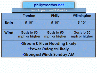
Modeling continues to suggest a coastal scrape or a track just inland with Irene as it moves north-northeast this evening and tonight. The Euro has a track just east of the Jersey coastline overnight. If the track of the center of the storm is inland a few miles, the sustained winds at the Shore could reach 60 mph or higher. Add another 20 mph in highest gusts and the potential for hurricane force gusts remain…especially if the center of Irene hugs just inland and allows those higher wind speeds to impact along the coast. Inland, the wind speed issues will be reduced but gusts to 50 mph or higher are certainly possible along and east of I-95, with lower wind gusts possible as one goes northwest of the city. Despite lower wind gust potential, the saturated ground and heavy rain will lead to fallen trees and power outages.
Update, 2:44 p.m. Delaware Governor Jack Markell has ordered the Indian River inlet bridge on Route 1 closed beginning at 4 p.m. Saturday. It will remain closed for several until divers can determine whether there was any structural damage from Hurricane Irene. Delaware officials now expect the First State to get 8-12 inches of rain. Here’s the full update from NewsWorks Delaware’s John Mussoni.
Update, 1:59 p.m. Here’s the latest update from NewsWorks.org weather blogger Tom Thunstrom of phillyweather.net:
One of the things to watch in this storm, as we’ve been talking about, is river and stream flooding. These projections show flooding over the next 48 hours along local streams and rivers in the Delaware Valley, with the potential for major flooding expected on a number of streams. The National Weather Service is projecting a top five river crest in Norristown along the Schuylkill and in Langhorne along the Neshaminy Creek. Those who flooded in Floyd may very well flood again in this storm as the soil conditions and heavy rains of late are very, very similar to those in ’99.
Tornado watch for extreme South Jersey and Delaware until 8 PM, possibly later. Radar shows rain now into Philadelphia and working north and northwestward. It took a little longer than I had anticipated earlier this morning but it’s here and it’s not departing for quite a while. Modeling from most of the guidance is in for the midday runs and things continue to stay on track with the storm regarding rain and timing that we outlined earlier today.
Rainfall in Southern Delaware has already topped an inch, much of it falling within the past two hours. Georgetown has picked up over an inch and a half, Dover is approaching a half inch so far. Heavier rainfall totals to the south and those will continue to propagate northward.
Update, 1:56 p.m. Irene is a Twitter-fest. Peter Crimmins reports on what media mockers, shopaholics and Kanye West fans, among others, are tweeing about the storm.
Update, 12:36 p.m. Residents of the flood-prone Venice Lofts apartment complex in Philadelphia’s Manayunk neighborhood have been ordered to evacuate the building by 5 p.m. tonight. The evacuation was issued because of the building’s proximity to the Manayunk Canal and Schuylkill River – the two have a long history of flooding.
As of Friday night, The National Weather Service’s Hydrologic Prediction Service predicted the Schuylkill River would reach 9.70 feet by 8 a.m. tomorrow, 14.90 feet by 8 p.m. and 11.70 feet by 2 p.m. Monday.
Update, 11:50 a.m. Here’s a review of key storm-related developments in the Philadelphia region: SEPTA plans to shut down all service at 12:30 a.m. tomorrow (Sunday). Several regional rail lines – Airport, Chestnut Hill West, Paoli/Thorndale, Trenton and Wilmington/Newark Regional Rail Lines – will suspend service at 5 today.
Mayor Nutter has declared a 6 p.m. curfew for all city parks and recreation centers, which will remained closed through the storm. The city has not issued any evacuation order, but urged residents of flood-prone areas to consider vacating. Among those areas are Cobbs, Pennypack, Tacony, Wissahickon and Poquessing creeks, Main Street in Manayunk, Kelly and Lincoln Drives, Linden Avenue near the Delaware River, and the Philadelphia Naval Base.
Red Cross shelters will open at 6 tonight at three sites in Philadelphia, two in Delaware County, two in Chester County, and three in Montgomery County. Some of them will accept pets. For the full list, click here.
Update, 11:20 a.m. NewsWorks and WHYY-FM are covering the storm from all angles. Here’s a summary of the diverse reports you can find elsewhere on the site or on 90.9 FM. (We’ll be on the air for extended newscasts throughout the day tomorrow.)
It’s one thing if the storm canceled your weekend plans for a barbecue. But what if the event you had planned was a wedding? Elizabeth Fielder talked to some New Jersey residents who face that predicament here.
Ever wonder how TV field reporters prepare for hurricane duty, standing there yelling into a mic while rain pelts and winds lash? Peter Crimmins talked to two TV reporters about how they do it.
Flooding remains a huge worry. Kimberly Haas reports that the worst of the stream crests might not hit until Monday or later.
Our Delaware bureau is all over the situation in the First State. Here’s their report on Gov. Markell’s evacuation order.
Update, 10:15 a.m. Officials with the Sussex County Government in Georgetown, Del., report Hurricane Irene has begun to make its way into the area, with conditions expected to worsen quickly as the day progresses. A hurricane warning in the area remains in full effect for all of Sussex County. Forecasters expected gradual weakening of the storm between landfall today and Sunday morning as the storm makes its way up the Delaware coast.
Update, 10:07 a.m. Who says the Philadelphia Parking Authority is staffed solely by heartless sons of guns? Yep, it took the approach of a Category 1 hurricane, but the authority that brought you Parking Wars is thinking of you in this criss. It just announced that it will offer free metered parking through the city during Irene’s visit, as well as a flat $5 rate at several of its garages.
The four garages are at 10th and Filbert, 10th and Ludlow, Eights and Filbert and JFK Plaza (aka Love Park). The flat rate begins at 5 p.m. today (Saturday), and ends at 5 a.m. Monday. Keep that entry ticket stub to claim the rate. Free metered parking began this morning at 8 and ends Monday morning at 8. Just so you don’t think they’ve totally lost their edge, authority officials warn that parking officers will still be out ticketing for illegal or unsafe parking.
Update, 9:45 a.m. The National Weather Service says as of 8 a.m., the center of Hurricane Irene was about 340 miles south-southwest of Atlantic City, New Jersey, or about 310 miles south-southwest of Dover, Delaware. The National Weather Service says its latest hurricane update is scheduled for noon, or earlier if conditions warrant.
Update, 8:15 a.m. NewsWorks’ Delaware editor and reporter John Mussoni reports as of 8 a.m., the weather was cloudy and humid near the Roth Bridge prior to Irene’s arrival. On Friday, cars jammed the roads as people left the beaches to avoid the storm. John Mussoni will continue to update us on conditions in Delaware.
Update, 7:30 a.m. President Obama has declared a declared an emergency for the State of New Jersey. The action was made Saturday and authorizes the Department of Homeland Security, and the Federal Emergency Management Agency (FEMA) to corrdinate all disaster relief efforts to help those impacted by Hurricane Irene. According to a news releease issued by FEMA, emergency protective measures, including directive federal assistance, will be provided at 75 percent of federal funding.
The fist band of the hurricane became visible on radar Friday as it moved closer to the Jersey Shore.
In parts of New Jersey and along the Jersey shore, residents can expect wind gusts of no less than 50 miles per hour with between 5-10 inches of rainfall. In Delaware, residents are bracing for win gusts reaching 80 miles per hour with as much as 10 inches of rain possible.
Emergency management officials recommend residents in Philadlephia and throughout parts of Pennsylvania, New Jersey and Delaware prepare for the storm.
BE PREPARED:
The National Hurricane Center has a checklist of things you should consider before a hurricane.
Develop a family plan
Create a disaster supply kit
Have a place to go
Secure your home
Have a pet plan
Below, we’ve attached the latest forecast models from Phillyweather.net and the National Weather Service’s National Hurricane Center.
From wind whipping through a TV reporter’s hair, to other TV reporters who are staying in areas they cleary should have evacutaed – we want to know what your favorite hurricane TV report is so far? Who has had the most interesting, or odd reports before the storm. Share your thoughts in the comments section below.
Video below show an example of what happened throughout the region during the deluge. It’s a “white water rapids” running through an apartment parking lot in Chestnut Hill.
WHYY is your source for fact-based, in-depth journalism and information. As a nonprofit organization, we rely on financial support from readers like you. Please give today.


