


Remnants of our industrial past

July 6
By Steven B. Ujifusa
For PlanPhilly
“A collision between a cathedral and a train station,” is what one observer noted of Frank Furness’ library for the University of Pennsylvania, completed in 1891 (i). Modern day architectural historian Michael J. Lewis further observed that the design language of the city’s greatest architect during its industrial heyday was one of power, aggression, even violence. Furness’ architectural language paid some homage to the past but thoroughly reveled in modern materials and construction techniques developed in the workshops and factories of Philadelphia, many of which lined the Delaware River.
The late nineteenth century was a time of celebration for the city; it was wealthy, bustling, and growing by leaps and bounds. The 1876 Centennial Exhibition was just as much a celebration of modern manufacturing methods as it was a tribute to American independence. Perhaps no one captured the optimism and confidence of the industrial Victorian Age better than Prince Albert, consort to Queen Victoria, who wrote in 1851 about the effects of technological progress:
“Nobody, however, who has paid any attention to the features of our present era, will doubt for a moment that we are living at a period of most wonderful transition which tends rapidly to the accomplishment of that great end to which indeed, all history points — the realization of the unity of mankind (ii).”
Prince Albert was referring to a world that was being brought together by science, industry, and transportation. Philadelphia was one city that took this vision of the world to heart. It was a city justly proud of its ability to manufacture and sell high quality goods not just to the nation, but to the whole world. These included everything from Baldwin locomotives to William Cramp ships to Stetson hats.
William Penn’s 1682 vision of a “green country towne” stretching river to river did not square with the necessities of commerce and industry that became Philadelphia’s lifeblood. Until the advent of the horse-drawn trolley in the 1830s, residential and commercial districts hugged the shoreline of the Delaware River. This created a city in which different classes and land uses were shoved cheek-by-jowl with each other. Even Philadelphia’s merchant elite had no problem living close to the waterfront’s dirt and noise. Stephen Girard, who died in 1831 as the richest man in America, had a house at 23 North Water Street with a counting room on the ground floor (iii). Here, as he kept track of his finances, Girard kept an eye on the longshoremen as they unloaded crates of valuable imports and hauled them over to the warehouse.

Figure 1. “The Pastoral State” from Thomas Coles’ “The Course of Empire” (1834). William Penn and his planner Thomas Holme originally envisioned Philadelphia as a spacious community of farmers, a direct contrast to congested, unhealthy London. The rules of commerce and industry would make this a short-lived vision.
The construction of the railroads and their massive freight and passenger complexes near Broad Street and on the banks of the Schuylkill in the mid-nineteenth century caused some industry to shift westward. However, the Delaware River port continued to prosper well into the 20th century, sustaining a variety of factories, warehouses, and other enterprises that required close access to the sea. During its industrial glory years, this waterfront was a muscular, rough, yet lively place. Its streets, alleys and waterfront were defined by hissing steam, clanking machinery, drifting coal smoke, blasting whistles, and sweating workers.
This was the world of most Philadelphians during the Victorian age, a society of determined, proud men and women who worked long hours in the factories, shipyards and piers. Many of them immigrants, they labored long and hard to provide a better future for their children. This brawny, working-class landscape, the flip side of the well-groomed, proper enclave of 19th century Rittenhouse Square, was especially evident on the Delaware waterfront. These piers and factories were built to last, as were the houses, churches, and other institutions were sustained by them.
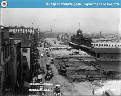
Figure 2. Delaware Avenue looking north from Chestnut Street, 1899. In its Victorian heyday, the waterfront bustled with commerce and industry. www.phillyhistory.org
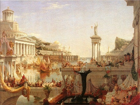
Figure 3. “Consummation of Empire” from Thomas Coles’ series “The Course of Empire” (1836). The allegorical resemblance between this fictional waterfront landscape and the previous image of the Delaware waterfront are obvious. http://www.swarthmore.edu/Humanities/kjohnso1/colecourse.html
The industrial waterfront’s decline during the mid-20th century was slow and drawn-out. It was punctuated by one catastrophic event in the late 1960s: the construction of I-95. This was the death blow to a waterfront already reeling from the loss of industrial jobs to cheaper labor markets and the rise of containerization, which rendered the old piers obsolete. The 1976 book Philadelphia Preserved, a compilation of work conducted by the Historic American Buildings Survey, notes many warehouses, factories, piers and other industrial buildings along the waterfront, especially in Old City and Society Hill. However, the majority of these entries are concluded with the terse phrase “Demolished 1967,” when I-95 crashed through the historic waterfront wards.
Today, most of the surviving industrial structures on the Delaware lie in various stages of disuse, decay or ruin, sitting in a no-man’s land of weeds and cracked concrete. Center City’s waterfront has been reduced to a museum and struggling recreation area. The remains of South Philadelphia’s port life are largely fenced off behind barbed wire, removed from public view and no longer physically integrated with the surrounding residential neighborhoods. Some industrial waterfront structures have found new uses, such as condominiums, playgrounds and storage facilities. Many are surrounded by newly-renovated row houses, restaurants and small businesses.
Industrial historian Phillip B. Scranton wrote: “If much of what we have is buildings and memories, both are worth preserving for uses that as yet lie only in our imagination (iv).” Much of the Delaware River’s industrial landscape has been lost, but there is still much to preserve for future generations. The buildings profiled in the article, which are lesser-known industry-related landmarks on the Delaware, might not have the architectural grandeur of Frank Furness’ library at Penn or Victorian row houses near Rittenhouse Square. However, they are worth saving because they are tangible reminders of the livelihoods of thousands of ordinary Philadelphians, who toiled in the factories, piers and power plants, back when the waterfront was the proud gateway to a city once known as the “Workshop of the World.”
The Delaware River Piers
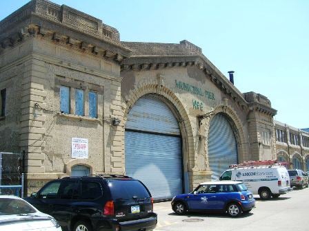
Figure 4. Municipal Pier Number 9, c. 1910. Delaware Avenue and Vine Street.
Figure 5. Monitor roof of Municipal Pier Number 9 as viewed from Delaware Avenue. Photograph by author.
Figure 6. The “Girard Group” municipal piers, constructed in the 1920s. Delaware Avenue and Market Street.
A century ago, Penn’s Landing was not the barren stretch of concrete and brick it is today, but a vibrant forum where the city’s goods were exchanged. The only real reminders of the nautical glory days are museum attractions: Independence Seaport Museum, the U.S.S. Olympia, the submarine Becuna, and the tall ship Moshulu. These ships are not docked at proper piers, but a concrete protective breakwater with a promenade on top.
The earliest Delaware piers were made of little more than wood pilings topped off by a plank deck, most of which have been destroyed. Starting in 1907, a number of larger, more permanent piers were constructed, part of a comprehensive plan to upgrade the Delaware River as a shipping channel. Along with building new piers, the plan included dredging the river to a depth of 35 feet all the way to Allegheny Avenue and the construction of the Benjamin Franklin Bridge.
By this time, Philadelphia had ceased to be a major port of departure for the crack transatlantic passenger steamers. The grandest passenger ships, some of which were approaching 900 feet in length, were departing from New York. Nonetheless, a number of smaller liners from the White Star and Red Star Lines departed from Philadelphia to Europe. In addition, the older freight piers were too small to dock increasingly larger cargo ships.
These new piers, meant to be grand gateways to the city, resemble the larger Chelsea piers in New York City, which were built around the same time. The head houses facing Delaware Avenue were constructed of poured concrete, and were decorated with arched entrances, baroque pediments, and rusticated bases. The piers themselves were two-story metal sheds topped with monitor roofs and catwalks. Each of these piers could accommodate ships up to 500 feet long, which in the early 1900s meant a large cargo ship or a small passenger liner (v). Their cranes were capable of hoisting up to 5 tons of cargo (vi).
Surviving examples of these 1907 passenger and freight piers include Municipal Pier Number 9 at Delaware Avenue and Cherry Street, which served as one of the passenger ship terminals, and the much larger Piers 38 and 40 at Delaware Avenue and Carpenter Street, which were meant to handle freight. With the exception of Pier 9, the concrete head houses of these piers have all been whitewashed.
In the 1920s, the head houses of two of the original Center City municipal piers, known as the Girard Group, were refaced in the Art Deco style with simplified Gothic motifs. Instead of poured concrete, the Girard Group used composite construction of yellow brick and concrete detailing. However, the construction of the actual piers was the same as the older ones: a two-story steel shed with catwalks above.

Figure 7. Piers 38 and 40 as originally-built, photographed in 1915. www.phillyhistory.org
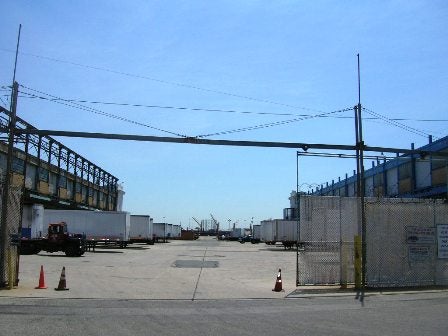
Figure 8. Rail, water and trucking converge at Municipal Piers 38 and 40. The one story section between the piers, shown in Figure 7, was demolished to make room for the concrete parking lot and truck loading dock. Photograph by author.

Figure 9. South side of Municipal Pier Number 40, at Columbus Boulevard and Queen Street. Photograph by author.
Figure 10. West façade of Municipal Pier 40, now a private indoor storage facility. Photograph by author.
Perhaps the most physically interesting of the municipal piers from a transportation standpoint are Piers 38 and 40. They are confluences of three of modes of transport: ships, rail and trucking. Early photographs of these two piers show that each one was an independent entity projecting into the Delaware River, connected by a one-story gallery facing the street. At some point, probably in the mid-twentieth century, the space between the two piers was filled in with concrete to accommodate tractor-trailers. The catwalk still survives on the south side of Pier 38, a reminder of its maritime days. Two sets of tracks connect this loading dock with the Columbus Boulevard rail line.
Gone are the days when ships lined the Delaware River from Oregon Avenue to Tacony. Most ships calling in Philadelphia dock at the piers south of Snyder Avenue, and unload their containers behind chain-link fences and barbed wire. Piers 38 and 40 have been converted to private storage facilities. The Girard Group piers are now condominiums and restaurants, while Pier 9 is neglected and crumbling.
A Man Full of Trouble Tavern
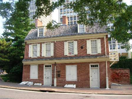
Figure 11. Man Full of Trouble Tavern, with Society Hill Towers in background. Photograph by author.
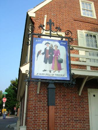
Figure 12. 18th century style tavern sign. Photograph by author.
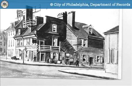
Figure 13. Man Full of Trouble Tavern, c.1835 sketch by W.L. Breton. The structures around the tavern have since been torn down. www.phillyhistory.org
The piers represent the waterfront at work. “A Man Full of Trouble Tavern,” although now no longer functional, is a rare historic survivor of the waterfront at play. It is one of what used to be scores of many such watering holes where ordinary Philadelphians congregated to enjoy their precious leisure time during the 18th and 19th centuries. The structure was built in 1759 by tavern-keeper Joseph Beeks, who leased the land from Michael Sisk. Like many an enterprising businessman, Beeks realized his Delaware waterfront location was prime real estate from which to sell his wares and services.
The first tavern in Philadelphia was completed in 1682, only a few months after William Penn had founded the city. Within a year, six more had sprung up (vii). By the time of the Revolution, the Delaware waterfront was lined with hundreds of these establishments. Regardless of their clientele, these taverns offered one thing in common: an alternative to the city’s foul and often unsanitary drinking water.
The discriminating middle and upper classes frequented such venues as the City Tavern at Second and Walnut, an imposing brick edifice that resembled a grand town house. Its public rooms, adorned with ornamental plasterwork and fine furniture, hosted members of the Continental Congress after-hours, as well as the Philadelphia Assembly dances. These taverns were more than just places to drink; they were social venues analogous to the modern day Ritz-Carlton. Political and business deals were made over a handshake and a glass of madeira.
The more common venues–located close to the piers, wharves and warehouses of the Delaware River–catered to sailors, stevedores, and other members of Philadelphia’s working class. Some of them were the cozy neighborhood establishments, where locals could escape such crowded living conditions and the physical strain of manual labor. Others were the modern day equivalent of the dive bar, bawdy houses that sailors would run to as soon as they received their pay and shore leave. Of course, many of these taverns doubled as houses of ill-repute, and contributed to the drunkenness, crime, and prostitution that infested sections of the Delaware waterfront.
The “Man Full of Trouble,” as its name suggests, probably catered to a fairly rowdy crowd in the 18th and early 19th century. The building had numerous tenants; in the 1830s it went by the names of “A Man Full of Mischief” and “Naylor’s Hotel.” In the 1960s, the deteriorated structure, then being used as a chicken market, was purchased by preservationist Virginia Knauer and restored to its 1759 appearance (viii). It is not currently open to the public. Although an attractive two-and-a-half story building in the Georgian style, it has been extensively sanitized since its “glory days”. Once packed in with other brick and wood-framed houses, it now sits isolated and alone, surrounded by a green space and the 1960s Society Hill Towers.
William Cramp and Son Ship and Engine Building Company

Figure 14. The last surviving structure of the William Cramp and Son Shipyards in Port Richmond, at Richmond Road and Girard Avenue. Photograph by author.

Figure 15. The William Cramp Shipyard in 1919, showing vessels docked for engine repair. www.PhillyHistory.org

Figure 16. The St. Louis, built by the William Cramp and Son Shipyard in 1894 for the American Line. At the time she and her sister St. Paul were among the largest passenger liners in the world and the pride of Philadelphia. http://www.oceanliner.org/st_louis.htm
One hundred years ago, the Delaware River was one of the premier shipbuilding areas in the United States, assembling first-rate vessels for both the merchant marine and the United States Navy. There are scant reminders of those glory days. Nothing remains of the original the Navy Yard, which was located on the current site of Municipal Piers 38 and 40 at Delaware Avenue and Carpenter Street.
With one exception, the buildings of the once-great William Cramp and Son Ship and Engine Building Company have been completely eradicated. William Cramp founded his shipyard in present-day Port Richmond in 1830, and his firm quickly prospered and became one of the leading privately-owned shipyards in the country (ix). Along with numerous cargo ships and naval vessels, the Cramp Shipyards’ most notable creations were the 11,000 ton liners St. Paul and St. Louis, completed in 1894 and for a long time the largest ships built in the United States. Cramp also won lucrative contracts with the United States Navy, which had its own shipbuilding facility in the South Philadelphia Navy Yard. At its peak in the 1890s, the 32-acre yard employed approximately 6,000 people, most of whom lived in the crowded row house neighborhoods surrounding the yards (x).
After World War I, demand for new naval vessels fell off drastically, in large part because of the Washington Naval Conference of 1922, which severely limited the naval capabilities of major nations. Rather than building new warships, the American government either scrapped their old ones or blew them up for target practice. In 1927, the beleaguered William Cramp and Son Ship and Engine Building Company laid off its workers and closed its doors. The neglected facilities were reactivated in 1940 by Harriman Ripley and Company as part of America’s remobilization for entry into World War II. After the war ended, the facilities were closed for good, and one of the great industrial facilities of Philadelphia faded into oblivion. It was one of the first of the great Philadelphia manufacturing institutions to collapse in the post-war era, the beginning of the complete disintegration of the city’s industrial base by the late 20th century.
One lone structure, a towering brick warehouse that judging by its construction was probably built c. 1915, stands watch over the site of the once-sprawling complex. It was a machine shop, as indicated by its very tall ceilings, massive paned windows, and large front door that has since been replaced by a loading dock. This structure is slated to be torn down for a new Girard Avenue /I-95 interchange. The demolition of this structure would be a tremendous loss to the city of Philadelphia, not just because of its association with a great Philadelphia company, but also because its size and location in a revitalizing area would make it a prime candidate for rehabilitation.
The Sparks Shot Tower

Figure 17. The Sparks Shot Tower, looking west on Carpenter Street. The recreation center is housed in the two-story brick portion. Photograph by author.
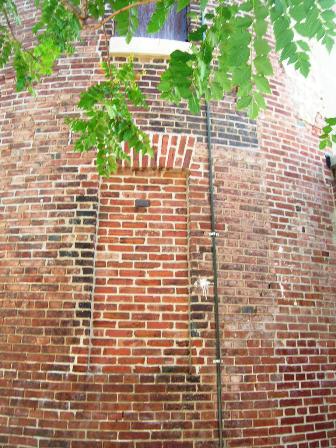
Figure 18. Close up of brickwork at base of the Sparks shot tower. Photograph by author.
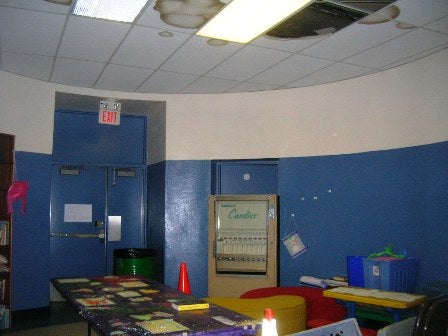
Figure 19. Circular children’s playroom at the base of the shot tower. This is where the water tank for cooling the molten shot was located. The shot tower itself cannot be accessed. Photograph by author.
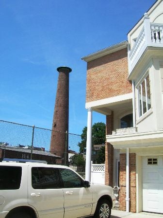
Figure 20. The industrial past and residential future of Queen Village? Photograph by author.
The Sparks Shot Tower is perhaps the best preserved example of 19th century industrial architecture in the formerly working-class, maritime district of Southwark, now known as Queen Village. It is located at Front and Carpenter Streets, dominating a neighborhood of early 18th century brick row houses, many of which were built by Swedish settlers. The shot tower, rising about 150 feet high, now forms the nucleus of a small playground that is well-utilized by the children of Queen Village during the summer months. It is separated from the grounds of Old Swedes Church and the Delaware River by the rumbling concrete barrier of I-95.
Easily mistaken for a factory smoke stack, the Sparks Shot Tower was for a long time the tallest structure in South Philadelphia. Constructed in 1806 by two Quaker families—Sparks and Bishop—the structure’s purpose was the manufacture of lead grape shot for hunters. Molten lead would be poured from the top of the tower and cascade through a wire mesh. The drops of lead would cool during their descent, until they finally landed in a tank of water at the bottom. Once cooled and finished, the shot would be packed into wooden crates, hauled to the Delaware River, and shipped by boat to its final destination. According to Frank Ward, a groundskeeper at the Shot Tower playground, there are still underground tunnels from the shot tower to the waterfront. These were probably meant to serve as a quick route to the docks, where the crates full of shot would be loaded onto the waiting ships.
In 1812, when America and Britain declared war on each other, the United States government requested that the Sparks-Bishop company manufacture shot for the American army. The Bishops, being devout Quakers, balked at manufacturing war supplies, and sold their interest in the company to the Sparks family. The tower also helped capture views of the city that were previously thought impossible. In January of 1870, a photographer carrying his cumbersome equipment climbed to the top of the shot tower. Here, he took four stunning panoramic photographs of South Philadelphia (xi). These images survive as wonderful reminders of the Delaware’s glory days during the waning days of sail.
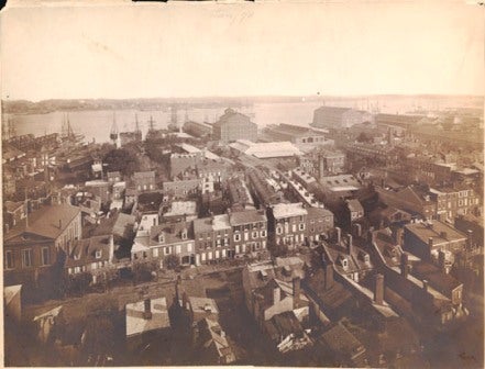
Figure 21. One of four panoramic views from the Sparks Shot Tower, 1870. Looking east towards the Delaware River, Old Swedes Church visible. http://libwww.library.phila.gov/HIP/HIPSearchItem.cfm?ItemID=pdcl00012
The Sparks family continued to manufacture shot at this location until the early twentieth century, when the structure was abandoned. The land around the shot tower was transformed into a playground for the children of the area around 1950. The first floor of the building was transformed into a community recreation center and indoor playroom for children, which it remains to this day. Sadly, the staircase that provides access to the top of the shot tower has long been closed to the public.
Queen Village Worker Houses
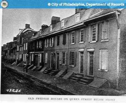
Figure 22. 18th century houses on Front Street in modern-day Queen Village, c. 1860. www.phillyhistory.org
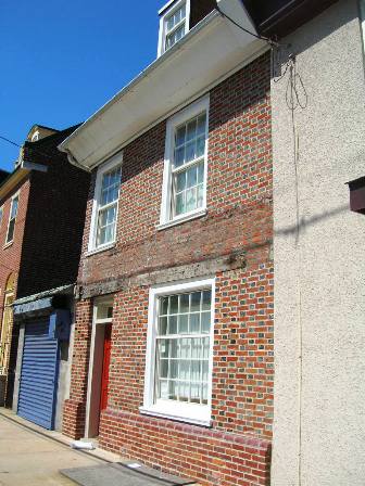
Figure 23. House built c. 1700 on Front Street near Carpenter. Note wood lintels above first floor windows and door. Photograph by author.
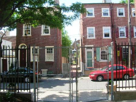
Figure 24. Houses on Carpenter Street, viewed through the gates of the Sparks Shot Tower playground. Photograph by author.
Until the trolleys appeared in the early 19th century and pushed fashion westward to Washington and Rittenhouse Squares, the most valuable land was closest to the Delaware waterfront. The Philadelphia row house was a practical way of maximizing the amount of revenue that could be squeezed out of a desirable parcel of land. Compared to apartments, row houses were relatively easy for absentee landlords to rent and manage. Alleyways cut through the facades of the street-front houses led to small courtyards in the rear that were packed with more dwelling units. A communal water pump usually was at the center of the courtyard. Naturally, these crowded living conditions were hazardous by today’s sanitary standards, leading to frequent epidemics of typhoid fever, cholera, and tuberculosis.
The small houses at the intersection of Carpenter and Front Streets are some of the earliest surviving Philadelphia row houses outside of Society Hill. These 18th century homes, originally occupied by the Swedish residents of the Southwark settlement, were originally only a stone’s throw from the docks. These two-and-a-half story homes were constructed for middle class workers and artisans. The earliest of these famous Philadelphia “trinity houses” typically had only one room per floor. This led to very cramped living conditions for a family. There was no escape from kitchen odors, and a privy located in the rear courtyard made matters worse. Crowding was exacerbated if a business was located on the ground floor or if they family took in borders.
Today, after decades of neglect and abuse, many of these modest workers houses have been restored to their original appearance by new residents of Queen Village. However, these houses are now completely divorced from their original context, cut off from the river by I-95. The construction of this highway in the 1960s, in addition to mowing down many industrial structures, destroyed hundreds of similar worker dwellings. In the past decade, expensive new construction has sprouted up in the vacant lots. Some of these new row houses are respectful of the area’s historic context and scale, while others might as well be in a typical suburban housing development. No matter, all of these builders are attempting to capitalize on the resurgence of an area that once was among the most economically valuable parts of town.
Edward Corner Marine Merchandize Warehouse
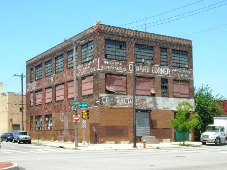
Figure 25. Edward Corner Marine Merchandize Warehouse at North Delaware Avenue and Shackamaxon Street.
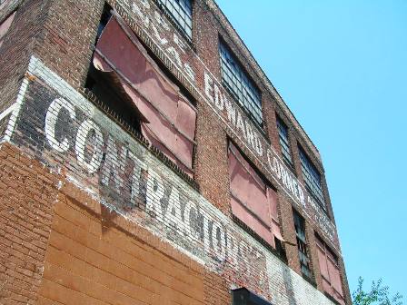
Figure 26. Close up of faded lettering advertising “Rope, Canvas, Anchors, Chain.” Photograph by author.
The Edward Corner Marine Merchandize warehouse is a utilitarian four-story warehouse fronting North Delaware Avenue in Fishtown, near the site of the demolished Jack Frost Sugar Refinery. Edward Corner purchased this corner lot on Shackamaxon Street around 1882. His marine supply business occupied this structure until 1960, when it was sold and converted into a furniture warehouse (xii). Like many deserted industrial buildings in Philadelphia, this building still retains the ghostly lettering of a business that no longer exists.
When Corner established himself in this neighborhood, merchant shipping was midway through its transition from sail to steam. Although steam power was faster, more reliable and efficient than sail, ship owners were notoriously conservative. Nineteenth century coal powered engines were expensive and prone to breakdowns. Boiler rooms were choked with vile, lung-blackening coal dust, and temperatures often rose to 120 degrees, making life miserable for the stokers. Many ship owners stubbornly continued to operate cargo ships powered either by sail alone or a combination of sail and steam. This nautical conservatism resulted in a Delaware waterfront lined with forests of masts and yards that lasted into the first few decades of the twentieth century. With the introduction of oil-fired engines in the 1910s, the steam engine finally killed what was left of the age of sail. Nonetheless, Corner probably found a brisk enough business in canvas and rope to advertise these sailing ship wares prominently on his façade until the very end.
The Ajax Metal Company
Figure 27. The main façade of the former Ajax Metal Company, at the intersection of Frankford Avenue and Richmond Road.

Figure 28. Close up of main pediment, showing the decorative limestone pediment and company name.

Figure 29. Modest row houses are being renovated directly across Frankford Avenue from Ajax. Photograph by author.
The former Ajax Metal Company is located in Fishtown at the intersection of Richmond Street and the southern end of Frankford Avenue. The first structure for the factory was built in 1894 and the complex continued to expand until 1950, when Ajax left Fishtown for good. Ajax was one of a series of businesses clustered on the southern end of Frankford Avenue that was engaged in metal smelting, providing steady employment for many Fishtown residents. Ajax in particular was engaged in tin, copper, zinc, and specialty alloys (xiii).
Although Ajax continues to survive as a company, its original headquarters is now abandoned and at the mercy of the elements. Like Corner’s warehouse, it is a utilitarian structure, built of brick and boxy in shape. Nonetheless, the beautiful classical limestone cornice and pediment at the top of the central section, with the company’s name proudly carved into the entablature, indicates that the original builders wanted to add some dignity and grace to their metal-smelting business. The two-story arched windows of the buildings wings, now bricked up, once let daylight flood into the smoky, noisy forge. Today, across Frankford Avenue from the broken windows of the Ajax Company, are several small three-story brick row houses. Once the residences of sheet metal workers, they are now being completely renovated, with new windows and roof deck penthouses.
The Delaware and Richmond Generating Stations
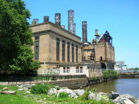
Figure 30. The abandoned Pennsylvania Electric Company Delaware Power Plant, with Penn Treaty Park in the foreground. Photograph by author.

Figure 31. View of south side of the power plant.
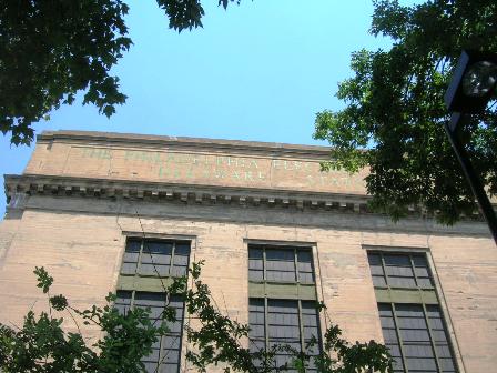
Figure 32. Faded green copper lettering: “The Philadelphia Electric Company Delaware Station”
Twin power plants, the Delaware and Richmond Generating Stations, stand as perhaps the mightiest monuments to Philadelphia industry on the Delaware River. In their day, their turbines were literally the engines that powered the industry of Fishtown and Port Richmond.
The Pennsylvania Electric Company Delaware Station, perched on the Delaware like a crumbling Roman ruin, was completed in 1917. Emulating their famous colleagues at McKim, Mead and White, designers of New York’s Penn Station, John T. Windrim and W.C.L. Eglin fashioned a concrete structure that blended classical ornamentation with state-of-the-art engineering and mechanical equipment. The coal used to power the turbines was hauled alongside the plant on barges then hoisted into the bunkers by a massive set of cranes perched on a pier. Keeping the bunkers full was no easy task; at its peak, the Delaware Station burned 325 tons of coal per hour (xiv).
Up the river was its twin, the Richmond Generating Station, completed in 1925 and also designed by Windrim and Elgin. Its heroically-named Turbine Hall is capped with a great glass and steel vaulted skylight that bears more than a passing resemblance to the long-demolished main concourse of New York’s Penn Station (xv). This “sanctuary” is filled not with a gilded statue of Jupiter but rather four gigantic steam turbines powered by twelve boilers. The total capacity for the power plant in its heyday was 600 megawatts.
Although the Richmond Generating Station is impressive in size, it was originally meant to be considerably larger. When the structure was completed, PECO projected that the new plant would eventually need three generating units. However, the construction of additional power plants on the Susquehanna River made these additional units unnecessary (xvi). The generating station continued to operate full-time until 1984, when it was largely shut down except for rare, peak load occasions.
The Delaware River Station, a classical monument to power and industry, also sits completely abandoned, its mighty stacks smokeless and rusting, its concrete walls crumbling, sumac trees growing out the cornices, and the great boilers and turbines cold and silent. During a PennPraxis design workshop in March, German architect Peter Latz put forward the idea of the station being transformed into a bio-gas generator (xvii). The businesses it once powered—shipyards, metal foundries, and sugar refineries—have almost all melted away. When darkness falls, a few of the Delaware River Power Station windows are still lit, an eerie reminder of a time when the whole building glowed against the night sky.
Penn Treaty Park lies just to the south of the Delaware River Power Station. Here, adults fish off a jetty and children play soccer and fly kites. The power plant, shrouded by trees, rises like an apparition above this pastoral setting, reminiscent of Thomas Coles’ “Desolation” painting from the series “Course of Empire.” In that work, vegetation sprouts from the ruins of once-grand structures, as nature has reclaimed her own and the waterfront has once again become a place of tranquility. Atop a lone classical column from a once-grand structure, bearing an eerie resemblance to the loading dock of the power station, a bird makes a nest for its young, a symbol of impending rebirth. No doubt many birds make their nests in the windows and cornices of the great tower of the station today as it awaits a new life, as does the once-mighty industrial corridor that was the Delaware River.
.

Figure 33. The Richmond Generating Station in all its glory, photographed in 1930. www.phillyhistory.org
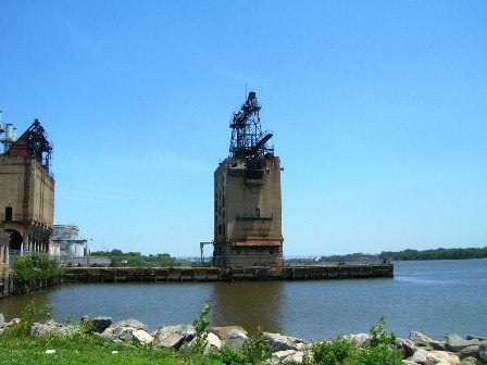
Figure 34. The Delaware Power Station today, as viewed from Penn Treaty Park. Nature is slowly reclaiming its own. Photograph by author.

Figure 35. Thomas Coles’ “Desolation,” The final in the series “The Course of Empire.” Such a landscape resembles sections of Penn Treaty Park, the Richmond and Delaware Generating Stations and the Delaware River today.
_____________________________________________________________
(i) Shelf Life – Frank Furness: Architecture and the Violent Mind – Review
http://findarticles.com/p/articles/mi_m1282/is_19_53/ai_78692097
(ii) The Speech of H.R.H. The Prince Albert, K.G., F.R.S., at The Lord Mayor’s Banquet, in the City of London, October 1849.
http://pages.zoom.co.uk/leveridge/albert.html
(iii) Richard J. Webster, Philadelphia Preserved: Catalog of the Historic American Buildings Survey (Philadelphia: Temple University Press), 1981. 41.
(iv) John A. Bowie, AIA (ed.), Workshop of the World (Wallingford: Oliver Evans Press), 1990. ii-8.
(v) Ibid, 6-14.
(vi) Ibid.
(vii) A Man Full of Trouble Tavern
http://www.ushistory.org/tour/tour_manfull.htm
(viii) Ibid.
(ix) Richard J. Webster, Philadelphia Preserved: Catalog of the Historic American Buildings Survey (Philadelphia: Temple University Press), 1981. 312.
(x) William Cramp and Son Ship and Engine Building Company
http://www.globalsecurity.org/military/facility/cramp.htm
(xi) Robert F. Looney, Old Philadelphia in Early Photographs 1839-1914 (New York: Dover Publications), 1976.
(xii) John A. Bowie, AIA (ed.), Workshop of the World (Wallingford: Oliver Evans Press), 1990. 4-18.
(xiii) Ibid, 4-8.
(xiv)Electrical Power and Corporate Identity: PECO’s Delaware Generating Station
http://ruins.wordpress.com/2006/11/10/electrical-power-and-corporate-identity-pecos-delaware-generating-station/
http://ruins.wordpress.com/2006/11/10/electrical-power-and-corporate-identity-pecos-delaware-generating-station/
(xv) Ibid, 4-10.
(xvi) Ibid, 14-11
(xvii) Changing Ideas – Ideas Aplenty – Just Add Politicians and Stir
http://www.philly.com/philly/entertainment/20070309_Changing_Skyline___Ideas_aplenty_-_just_add_politicians_and_stir.html
WHYY is your source for fact-based, in-depth journalism and information. As a nonprofit organization, we rely on financial support from readers like you. Please give today.
Brought to you by PlanPhilly

PlanPhilly
In-depth, original reporting on housing, transportation, and development.

Henry Tetlow helped shape America’s cosmetics industry with more affordable — less caustic — face powders before his company collapsed into a family feud.
1 month ago

West Philly tenants are racing to save 925 affordable rentals to prevent mass displacement
The subsidized units are among 12% of properties in the city that could lose their affordability restrictions over the next decade.
3 months ago
Listen 1:03
From firewood to solar: This Philly rowhouse has seen over 250 years of energy transitions
A rowhouse built around 1760 in Old City was once heated with firewood. Now, it has solar panels on its roof.
5 months ago
Listen 1:22