Persistent onshore flow to likely spur several cycles of minor tidal flooding

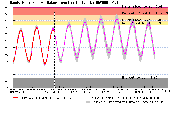
A plot for Sandy Hook indicating minor tidal flooding by tomorrow morning. The forecast is similar for the remainder of the Jersey Shore. (Image: Stevens Institute of Technology)
Forecasters expect a persistent onshore flow to develop tonight that will likely generate several cycles of minor tidal flooding.
National Weather Service forecasters expect the strongest winds tomorrow and Friday. NOAA is calling for sustained winds up to 30 miles per hour and gusts as high as 40 miles per hour during both days. Today’s northeasterly wind will turn easterly tonight into tomorrow before turning northeasterly tomorrow night into Friday.
“Tides levels are forecast to increase through this period, and we could reach minor coastal flood levels,”
Tides will also be higher than normal due to the influence of the Saturday’s new moon.
The Stevens Institute Flood Advisory System is forecasting high tide to approach minor tidal flooding levels at Sandy Hook during the Wednesday evening cycle. By Thursday morning, the forecast calls for minor tidal flooding, increasing slightly for Thursday evening and Friday morning before slightly dropping by Friday night.
The graph shows a similar tidal impact for Atlantic City oceanfront and the backbays, although tidal departures could be slightly higher along some backbay locations.
Residents of low-lying areas should move their vehicles.
Periods of showers are on the tap through at least Friday, and high temperatures will reach around 70 degrees.
WHYY is your source for fact-based, in-depth journalism and information. As a nonprofit organization, we rely on financial support from readers like you. Please give today.

