NWS: Snow might fall at one to three inches an hour on Wednesday

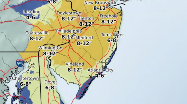
Monday afternoon NWS snow forecast.
Get prepared for potentially heavy snow on Wednesday.
The National Weather Service says confidence has increased to “high” that a winter storm will occur on Wednesday.
According to a late Monday afternoon briefing, a wintry mix will arrive on Tuesday, transitioning to snow on late Tuesday night through Wednesday morning, then snow from Wednesday afternoon through the evening hours.
Moderate to heavy snowfall is possible on Wednesday, potentially falling at one to three inches an hour. A general six inches to a foot is possible by Wednesday night, with lower accumulations in southern Shore areas. Forecasters say the current prognostication is at a medium confidence level.
The correct High end / Low end slide for the previous briefing package. pic.twitter.com/O2hYXRiWkN
— NWS Mount Holly (@NWS_MountHolly) March 19, 2018
The snow will be wet and heavy and difficult to shovel along with collecting on trees and wires, according to the briefing.
In Shore areas, the National Weather Service says snow will have trouble accumulating during daytime hours due to the “high late March sun angle and marginally cold surface temperatures except when the rates are moderate to heavy.”
Winds will be out of the northeast on Tuesday night, switching to the north on Wednesday then northwest on Wednesday night. Winds will gust between 30 and 40 miles per hour before decreasing to 10 to 20 miles per hour on Wednesday night.
In addition, minor flooding is possible with Tuesday night’s high tide, and moderate flooding is possible on Wednesday.
WHYY is your source for fact-based, in-depth journalism and information. As a nonprofit organization, we rely on financial support from readers like you. Please give today.


