


Detroit: Doing right by the waterfront

Mar. 2
Postcard from San Francisco
Postcard from Pittsburgh
Postcard from Germany
Postcard from China
Postcard from New Orleans
Postcard from Boston
By John Davidson
For PlanPhilly
When it comes to city planning and urban environments, Detroit isn’t usually the first place to look for examples of how to do it right. Not that there hasn’t been some creative revitalization downtown in recent years, but significant sections of the city’s core were abandoned or razed long ago, and remain that way—part of Detroit’s troubled history, which it is now struggling mightily to overcome.
Part of that tension is playing out on the city’s waterfront. Like Philadelphia, Detroit has a sizeable, underused waterfront, which is in the process of being renewed and reinvented as a center of civic life and pedestrian use.
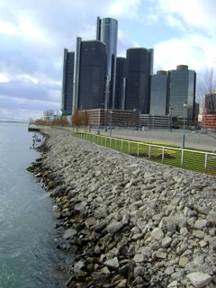
The Detroit River, like the Delaware River, was once a bustling center of shipping and commerce. In the early 20th century, the river was dubbed “The Greatest Commercial Artery on Earth,” with more shipping tonnage passing through the Motor City than either New York or London. Later in the century, as everyone knows, the city fell on hard times and the river’s industrial might declined. The waterfront languished there as it did in Philadelphia—a unique urban asset cut off from residents and the life of downtown.
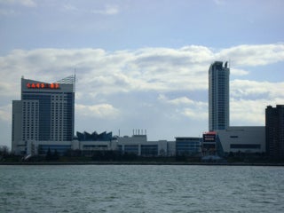
A view looking across the Detroit River at Windsor, which boasts a highly-developed waterfront with its renowned Riverfront Bike Trail.
But Detroit, ever the city committed to renaissance, began to change things. In 2003, the powers that be commissioned a study that resulted in the creation of the Detroit Riverfront Conservancy (http://www.detroitriverfront.org ), a public-private partnership whose stated purpose was to clean up and improve the city’s waterfront. It identified an area designated as the Detroit International Riverfront, which extends from the Ambassador Bridge to the Gabriel Richard Park, just east of the Belle Isle Bridge, about a five-mile span of waterfront next to downtown.
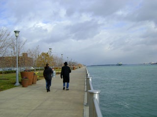
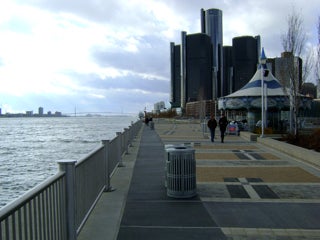
The RiverWalk looking east from near the GM Renaissance Center.
The DRFC’s efforts have thus far focused largely on the RiverWalk, a continuous expanse of parks, promenades and green spaces. The East Riverfront, a 3.5-mile span from the Joe Louis Arena to Gabriel Richard Park near Belle Isle, has seen the lion’s share of development, which began in earnest in 2007. Since then, various public spaces have been opening along the river and connecting waterfront landmarks like the Renaissance Center, GM Plaza and Tri-Centennial State Park (http://www.michigan.gov/dnr/0,1607,7-153-10365_24648-94491–,00.html )with a patchwork of wide promenades, parks and large pavilions.
The development of Detroit’s riverfront actually stands in contrast, in terms of scale, to much of the rest of the city. Built to service the automobile, Detroit is not laid out with pedestrians in mind: wide swaths of pavement cut through downtown, making travel by vehicle a near necessity. Not so with the new RiverWalk; it is in every way built to a human scale, catering to walkers, bikers, strollers and joggers.
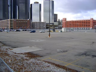
The RiverWalk development plan includes transforming parking lots like these near the waterfront into green spaces, and in some cases, into luxury housing developments.
Part of the RiverWalk construction has involved reclaiming vast downtown parking lots that nearly abut the riverbank. In their place will eventually be wide swaths of green space and footpaths leading to the water. In fact, if the design principles employed on the city’s waterfront were somehow extended throughout the city, Detroit would be the picture of a modern, sustainable urban center.
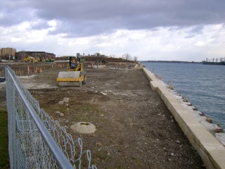
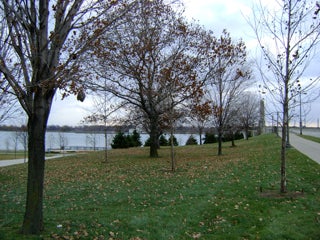
A park under construction near Rivard Plaza.
The success of the project is instructive for Philadelphia—or any modern city with a post-industrial waterfront. Detroit’s now-bustling, pedestrian-centered waterfront, once designed and built entirely for industrial use, now includes the former grounds of factories like the Uniroyal tire plant and Medusa cement company. Private land that had impeded public access to the river was acquired.
Rivard Plaza looking toward the GM Renaissance Center.
The waterfront’s economic appeal now lies in how it can serve individuals, both as a place to exercise and play, and as a focal point for festivals, concerts, and outdoor exhibits. Among the more popular events held on the riverfront are GM Days (http://detroitriverdays.com/), a four-day festival that draws some 700,000 attendees annually; and Rockin’ on the Riverfront, which brings free Friday concerts beginning in April (http://www.gmrencen.com/). The East Riverfront has also helped bring in private development; million-dollar condos like Watermark Detroit (http://www.watermarkdetroit.com/ ) are going up, enticed partly by the appeal of a vibrant, active waterfront.
A recently completed section of the RiverWalk near GM Plaza
That said, development of the East Riverfront has not been cheap. To date, the DRFC has raised $102 million toward its capital campaign goal of $140 million. The most recent contribution came in December, when Wayne County contributed $1 million. But money needs to keep coming in if work is going to move forward. In September, construction began on the expansion of Tricentennial State Park and Harbor—a project managers have said will take 275 days to complete.
Gabriel Richard Park, the eastern most point for the RiverWalk, is located just east of the Belle Isle Bridge and directly across the Detroit River from Belle Isle. The DRFC recently improved the park with a plaza and pavilion.
But so far, Detroit’s ambitious waterfront plan seems to be working. The use of a public-private partnership in the form of the DRFC is analogous, in many ways, to Philadelphia’s Action Plan for the Central Delaware. That plan, crafted by the Central Delaware Advocacy Group and Penn Praxis, in cooperation with city residents, will see funding from both public and private sources in the coming years, much like the DRFC’s East Riverfront plan has.
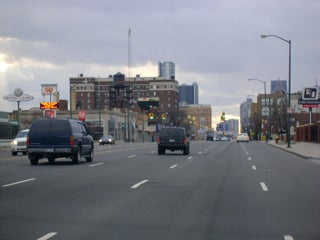
Once you get away from the waterfront, much of Detroit is built for vehicles. In contrast to the walkable, pedestrian-scale riverfront, Detroit has many wide, multi-lane streets cutting through its downtown.
And if Detroit’s experience is any indication, then it just might work.

John Davidson is the managing editor for Keystone Edge, a website that covers the new economy in Pennsylvania. Prior to that he wrote and produced digital video for digphilly.com. Davidson moved to Philadelphia from Wilkes-Barre, Pa., where he was a general assignment reporter for the Times Leader. He has also worked as a reporter for newspapers in Chicago and Alaska, his home state. Contact the reporter at jddavidson9@gmail.com
WHYY is your source for fact-based, in-depth journalism and information. As a nonprofit organization, we rely on financial support from readers like you. Please give today.
Brought to you by PlanPhilly

PlanPhilly
In-depth, original reporting on housing, transportation, and development.

South Jersey woman opts for mediation in eminent domain fight over her Whitesboro property
Dawn Robinson has been fighting efforts from the city to force her to sell her 2.4-acre property in Middle Township.
4 weeks ago
Listen 0:57")
Philadelphia is technically a buyer’s market, but housing economists say that’s misleading
Sellers are less serious, and buyers can’t afford anything. Economists say it will likely take years for things to improve.
1 month ago

What lower interest rates mean for homebuyers
Mortgage rates dropped below 6% last week for the first time in years, a sign that some economists believe will trigger a more active and competitive housing market.
Air Date: March 3, 2026 12:00 pm
Listen 51:41