Tropical Storm Warning in effect: Here’s the latest on potential impacts

A Tropical Storm Warning is in effect for the Jersey Shore.
According to the National Weather Service, a Tropical Storm Warning means that “sustained winds of 34 to 63 knots (39 to 73 mph or 63 to 118 km/hr) are possible within the specified area within 36 hours in association with a tropical, subtropical, or post-tropical cyclone.”
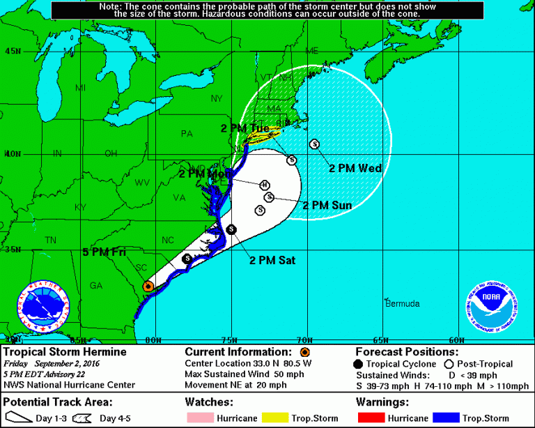
The latest National Hurricane Center forecast as of 5 p.m. today is in the image above. New Jersey remains within the National Hurricane Center’s “cone of uncertainty” for potential impacts from what is currently Tropical Storm Hermine.
The storm is expected to once again regain hurricane status with 75 mile per hour winds off the Delamarva at 2 p.m. Monday, according to the track.
According to the latest track, the storm is expected to wobble westward closer to the coast between Sunday afternoon and Monday at 2 p.m.
Here are the current hazards according to the latest National Weather Service briefing:
Coastal flooding/beach erosion: High Confidence.
Areas of minor flooding beginning with the Saturday evening high tide, then minor to moderate flooding Sunday morning and evening. Widespread moderate flooding Monday morning, with areas of major flooding especially from Atlantic City south to coastal Delaware. Coastal flooding may continue into Tuesday.
Given multiple rounds of tidal flooding, water in the back bays will have a hard time draining between tidal cycles which should lead to prolonged and significant flooding in these locations. Additionally, there could be tidal flooding into the upper portions of Delaware Bay and the tidal Delaware River, including Philadelphia.
The combination of higher than normal tides and heavy rain will cause flooding of streets and low lying places in the coastal areas this weekend. Be careful where you park your car. Significant beach erosion expected due to large wave action and this prolonged event.
Read the full briefing for specifics on tidal flooding.
Strong wind: Moderate confidence.
Tropical storm force winds, sustained wind of 39 mph or greater, with higher gusts for at least the coastal counties (areas under the warning). Strongest winds should occur Saturday night into Monday. A further west track would bring stronger winds more inland, however the winds are expected to decrease quite a bit further inland.
Heavy rain: Moderate confidence.
A sharp western cutoff of the heavy rain is expected, and this will be dependent on the exact track. Areas with the highest risk for heavy rain are Delmarva and eastern New Jersey. The heaviest rain should occur Sunday into Monday. The primary flooding hazard will be street and flash flooding. The recent dry weather will lessen but not eliminate the risk of river and stream flooding.
Rip current risk: High Confidence.
Moderate to high risk through at least Labor Day, and may continue Tuesday . Beach goers should only enter the water if lifeguards are present, and as conditions worsen are urged to stay out of the water. High and dangerous surf is expected.
Stay tuned for updates from Jersey Shore Hurricane News (JSHN) and here.
WHYY is your source for fact-based, in-depth journalism and information. As a nonprofit organization, we rely on financial support from readers like you. Please give today.

