Strong coastal storm likely for midweek; many details still uncertain

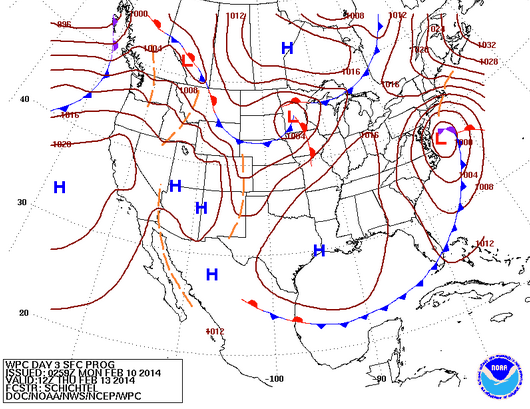
The "Day 3" forecast issued by the National Weather Service Weather Prediction Center. The map depicts 7 a.m. Thursday.
Forecasters expect a strong coastal storm to track up the Mid-Atlantic coast Wednesday night into Thursday, but details remain fluid.
What ultimately happens in the New Jersey region is highly dependent on the storm’s track, according to the National Weather Service office in Mount Holly, NJ.
The Hazardous Weather Outlook issued by the service Monday morning discusses the possibility of heavy snowfall along the Interstate 95 corridor Thursday morning, with precipitation potentially becoming mixed inland and sleet or rain near the coast for a period if the storm tracks within 50 miles of the coast.
Northeast winds may potentially gust up to 45 miles per hour along the coast, but wind speeds are also dependent on the track. With onshore winds and a full moon, some tidal flooding is also likely, according to a tweet from NBC40 meteorologist Dan Skeldon.
The storm track and precipitation types will be “more accurately determined with time,” the service advises in its Monday morning Forecast Discussion.
What is much more certain is that the storm will move away from the region later in the day on Thursday.
WHYY is your source for fact-based, in-depth journalism and information. As a nonprofit organization, we rely on financial support from readers like you. Please give today.

