Early spring? Mild temperatures will begin this weekend, continue through end of the month

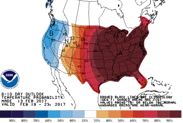
NWS Climate Prediction Center image.
Punxsutawney Phil saw his shadow this year and called for six more weeks of winter, but his prediction is now in doubt.
An early spring is now possible as global weather forecasting models are indicating above normal temperatures beginning this weekend through at least the end of February.
The average high temperature for that period at the Jersey Shore begins in the middle 40s and nears the upper 40s at the end of the month.
National Weather Service’s Climate Prediction Center is calling for a 90 to 100 percent chance of above normal temperatures between February 19 through February 23.
From there, there’s a 70 to 80 percent change from the end of that period through February 27.
The mild stretch will start on Sunday, when temperatures at the Jersey Shore will be approaching 60 degrees thanks to warmer air flowing in from the south.
But while forecasters do not expect any prolonged Arctic blasts through the end of February, a quick transient cool down is always possible.
Generally quiet weather is on tap for the remainder of this week, and there are no snow storms in the long range forecast.
It’s not yet known if March will feature cooler than normal weather, seasonable temperatures, or a continuation of above normal temperatures.
But what is now likely is that meteorological winter, the coldest three months between December and February, will not end chilly.
Spring begins on March 20.
WHYY is your source for fact-based, in-depth journalism and information. As a nonprofit organization, we rely on financial support from readers like you. Please give today.

