Tropical Storm Karen: What the New Jersey area needs to know

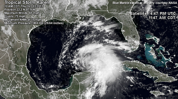
Tropical Storm Karen at 10:00 a.m. CDT today. (Image: Weather Underground)
Tropical Storm Karen, the eleventh named storm of the 2013 Atlantic hurricane season, formed in the southeast Gulf of Mexico Thursday.
The tropical system is expected to head toward the United States, with most forecasting models predicting landfall somewhere along the western Florida panhandle later in the day on Saturday, although the EURO model is currently indicating landfall over eastern Louisiana, according to a blog post by Weather Underground’s Dr. Jeff Masters.
The latest National Hurricane Center forecast has Karen making landfall as a tropical storm, defined as maximum wind speeds at the center of circulation between 39 and 73 miles per hour.
Karen is expected to encounter atmopsheric conditions that are not conducive to the storm possessing hurricane strength at landfall, Masters notes.
Once Karen makes landfall, the system is expected to head toward the northeast, when it could have a nuisance-level impact on the New Jersey region Monday into Tuesday as the storm’s remnants interact with an approaching cold front.
Not Sandy. Not Irene. Not a bad nor’easter.
For now, heavy rain is the expected storyline for early next week, although the system’s final track is currently unknown, according to Gary Szatkowski, chief meteorologist at the National Weather Service office in Mount Holly.
“With [the] formation of Tropical Storm #Karen, [the] main potential impact for our region is rainfall. Higher range of ensemble guidance – 2 to 4 inches,” Szatkowski tweeted today. “Rainfall timing if #Karen impacts [the] region would be Monday night into Tuesday.”
“Still plenty of time for things to change. Keep [an] eye on [the] forecast.”
So there you have it.
WHYY is your source for fact-based, in-depth journalism and information. As a nonprofit organization, we rely on financial support from readers like you. Please give today.

