Forecasters: Myriad weather threats Friday

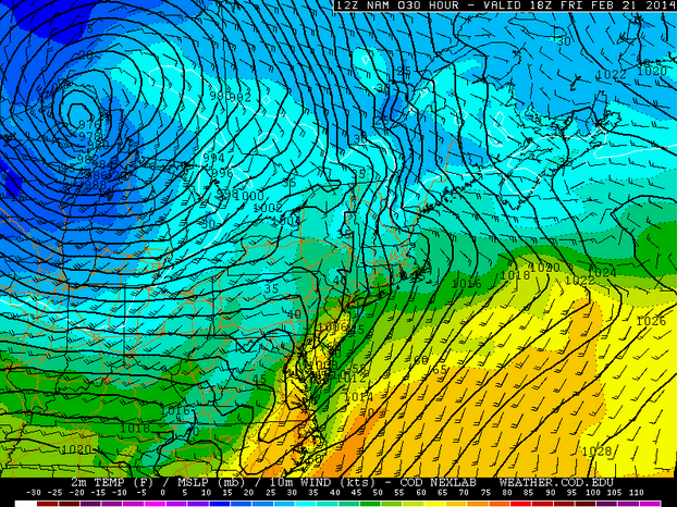
NAM model showing temperatures near 60 degrees in parts of New Jersey on Friday ahead of a cold front. (Image courtesy of New York Metro Weather)
The warmest day in recent memory may also deliver a multitude of weather threats, forecasters say.
Temperatures could rise to near 60 degrees in portions of southern New Jersey, southeastern Pennsylvania, and Delaware ahead of a cold front Friday, according to the NAM forecast model.
But consequences abound with the unseasonably warm temperatures, said John Homenuk, lead meteorologist at New York Metro Weather.
There is a 5% chance of severe thunderstorms for the vast majority of New Jersey, eastern Pennsylvania, and the northern half of Delaware, according to the National Weather Service Storm Prediction Center. For Cape May County and the southern half Delaware, there is a 15% chance of severe thunderstorms. Northwest New Jersey is not within a risk area.
But there’s more than just unusual February thunderstorms. Homenuk explains:
Storms. A cold front will move through the area later on Friday. Increased forcing/lift along this front will act as an impressive trigger for storms — and southerly flow ahead of the front will likely provide adequate instability for at least elevated thunderstorms in those areas. A very impressive mid and low level jet just above our heads provides the potential for strong winds to mix down to the surface in any thunderstorms. Although widespread strong/damaging winds aren’t expected, a few severe gusts seem likely but will remain isolated. The threat drops off farther north where instability is less, although rumbles of thunder and heavy rain are still likely along the front.
Flooding. Deep snow pack, especially across the interior, will begin to melt with the warmer temperatures on Thursday and may immediately create flooding problems especially if there are drainage backups. This is a good time to clear your gutters, drains and associated apparatuses to avoid interior flooding. The threat for rain on Friday will only compound the threat — as the snowpack will begin to compound and melt further. Poor drainage areas and blocked drains will have significant flooding problems during the heavy rain on Friday.
Dense fog. There is potential for dense fog on Friday morning with southerly winds ahead of the incoming front. Although not a “classic” dense fog signal, the potential exists for patches of dense fog especially with the snowcover in place. All in all, an active pattern continues — and it will bring the potential for hazardous weather even despite the warmup and lack of snow falling. Be aware for the potential of fog, flooding, heavy rain, thunder and gusty winds on Friday
So while Friday is shaping up to be an active weather day, “enjoy the warmer weather on Thursday first,” Homenuk suggests.
WHYY is your source for fact-based, in-depth journalism and information. As a nonprofit organization, we rely on financial support from readers like you. Please give today.

