

Sally becomes a hurricane; slow-moving storm already drenching Gulf Coast

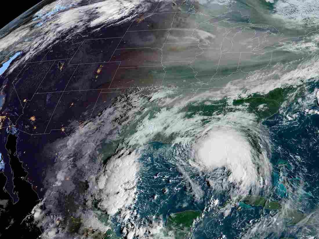
Sally is forecast to make landfall on the Gulf Coast, possibly in the area east of Gulfport, Miss. (NOAA/Esri/HERE/Garmin)
Updated at 12:35 p.m. ET
Hurricane Sally has formed off the U.S. coast of the Gulf of Mexico after the storm strengthened late Monday morning. Some coastal areas in Louisiana, Mississippi, Florida and Alabama are already seeing floods from the slow-moving storm, and forecasters said there’s more to come.
“Impacts of an extremely dangerous and life-threatening storm surge, hurricane-force winds and torrential rain with flash flooding from Sally will likely begin later today,” the National Weather Service said Monday.
The surge could be as high as 11 feet in some areas. The storm will also bring a huge amount of rain — from 8 to 16 inches, with up to 24 inches in isolated areas of the central Gulf Coast and the western Florida Panhandle.
National Oceanic and Atmospheric Administration and Air Force Reserve Hurricane Hunter aircraft confirmed that Sally had rapidly strengthened, the National Hurricane Center announced at 11:30 a.m. ET.
“The maximum sustained winds are near 90 mph (150 km/h) with higher gusts,” the center said. “Additional strengthening is forecast during the next day or so.”
Forecasters said conditions are too unstable to predict exactly where the storm will arrive. Current projections show Sally coming ashore east of Gulfport, Miss. The predicted track has shifted consistently eastward in the past 24 hours, bringing a measure of relief to people in southwestern Louisiana, which is still recovering from Hurricane Laura in late August.
Sally’s effects are already being felt in Florida, where it will likely continue to create flash floods across the peninsula, the hurricane center said. The storm is adding to major flooding already happening across western and central Florida, the agency said.
🛰 With the sun coming out we can now get a visible image of #Sally. The latest explosion of storms close to the center has produced an impressive image of gravity waves emanating in all directions. This would suggest #Sally is trying to strengthen; we shall see what Recon finds. pic.twitter.com/koyZzDzf9k
— NWS New Orleans (@NWSNewOrleans) September 14, 2020
As of late Monday morning, Sally was about 165 miles southeast of Biloxi, Miss., moving west-northwest at 7 mph. Its maximum sustained winds were 90 mph.
Sally is one of five named storms the agency is tracking – tying a record from September 1971 for the most tropical cyclones at one time, according to senior hurricane specialist Eric Blake of the hurricane center. The newest is Tropical Storm Vicky, which developed late Monday morning.
I cry uncle. 2020 please stop! Storms everywhere 👀 pic.twitter.com/iqSnIudIYs
— Eric Blake 🌀 (@EricBlake12) September 14, 2020
Hurricane Paulette made landfall on Bermuda early Monday, bringing sustained winds of at least 90 mph with higher gusts, the hurricane center said. At around 5 a.m. local time, the entire island was inside the storm’s eyewall. The storm’s center is now moving north-northwest away from the island, but dangers persist from strong winds and heavy rain that are still to come.
“Please stay hunkered down Bermuda,” the Bermuda Weather Service said Monday morning.
People in Bermuda should remain indoors until at least Monday afternoon, the National Hurricane Center said, warning that “winds will increase suddenly from the southwest.”
The massive amount of water Sally brings will pose a perilous threat in the form of flooding from its storm surge and heavy rainfall. Heightening that risk, the storm is expected to continue to move slowly, increasing the impact of its rainfall.
“Life-threatening flash flooding is possible and widespread minor to isolated major flooding on area rivers is likely along and just inland of the Central Gulf Coast,” the National Hurricane Center said.
A storm surge warning is in effect from Port Fourchon, La., to the Alabama-Florida border, including several lakes and Mobile Bay. A hurricane warning is in effect from Morgan City, La., (west of New Orleans) to the Mississippi-Alabama border.
Parts of Mississippi and Alabama will also see the risk of significant flash and urban flooding through the middle of the week, the National Hurricane Center said.
“Life threatening surf and rip currents have begun along our beaches this morning,” said the National Weather Service office in Mobile, Ala. “Waves will continue to increase throughout the day and DOUBLE RED flags are flying at all of our beaches. Stay out of the water!”
🌊 Life threatening surf and rip currents have begun along our beaches this morning. Waves will continue to increase throughout the day and DOUBLE RED flags are flying at all of our beaches. Stay out of the water! https://t.co/Hjf7eyQiaX
— NWS Mobile (@NWSMobile) September 14, 2020
“The window of time you have left to get ready is quickly closing,” Louisiana Gov. John Bel Edwards told residents Sunday night. Edwards declared a state of emergency over the weekend; he has also asked President Trump to declare a federal emergency.
“The storm is expected to impact New Orleans, where the state is currently housing more than 12,000 Hurricane Laura evacuees in hotels,” NPR member station WWNO reported.
Overall, the hurricane center is tracking seven systems — the five named storms and two disturbances that have only small chances of developing over the next 48 hours.
Tropical Storm Teddy formed in the distant Atlantic Ocean overnight and is expected to become a major hurricane – but its forecast path veers northward away from the Caribbean and over the open water, and it’s not yet certain what dangers it could bring to any populated areas.
At this early stage, Teddy is expected to follow a similar path to Paulette’s, although with a sharper turn to the north.
The other named storm is Tropical Storm Vicky – which formed Monday morning but is expected to devolve quickly. Rene is experiencing a similar fate; it was declared a tropical depression over the Atlantic on Monday.
9(MDAzMzI1ODY3MDEyMzkzOTE3NjIxNDg3MQ001))

Tropical storm warning issued for US East Coast ahead of potential cyclone, forecasters say
The National Hurricane Center announced the emergence of “Potential Tropical Cyclone Sixteen” on Thursday morning.
7 months ago

Tropical Storm Hilary makes landfall along Mexico’s Baja coast, carrying deluge to California
It's no longer a hurricane but still carries so much rain that forecasters say “catastrophic and life-threatening.”
8 months ago

Frigid monster storm across US claims at least 34 lives
The National Weather Service says about 60% of the U.S. population has faced some sort of winter weather advisory or warning.
1 year ago